


Looking for a quiet walk in the woods? Complete with a pristine 40-acre pond at the end of the trail? Mountain Pond in Rangeley Plantation is a good choice. Well-known to locals, the Mountain Pond Trail offers a 1.5-mile (3.0 miles round trip) steady ascent, gaining over 700’ of elevation between the trailhead and the pond. In the process the trail passes through both hardwood-softwood transition forest, and a sub-alpine fir and spruce forest, to end at the east shore of Mountain Pond.
Reaching the Trailhead
With fall in the air, and the first of the red maples in color change, I take my first hike on the Mountain Pond Trail. The trailhead is off the Edelheid Road, which heads west off Maine Highway 4, at a distance 3.4 miles south of the Whip Willow Farm Overlook in Rangeley. For those heading north, Edelheid Road is 1.5 miles north of the Highway 4 boat launch on Beaver Mountain Lake. Drive 0.5 miles on the Edelheid Road, which changes from paved to gravel surface. Or count the power poles! The trailhead is at the 13th pole.
Parking is along the road. A prominent sign, next to a bench seat, marks the start of the trail. The route is blazed with red paint stripes on trees or on cairns. I find the route to be well-worn and straightforward to follow. The trail is well maintained by volunteers of the Trails of the Rangeley Area Collation (TRAC). This organization also hosts weekly hiking, paddling, or mountain biking outings in the Rangeley Region – an important asset to the outdoor community. (See the end of this article for contact information.)
On Trail
I make my way through mixed hardwood and softwood forest, the transition zone between the rock maple, red maple, yellow birch, white birch, and other hardwoods found at lower elevations, and the balsam fir and red spruce, which predominate at higher elevations. The trail follows the remains of an old woods road under the forest canopy, well shaded. There are no other vehicles parked in the area, and no one else on trail. I have the trail to myself!
Five minutes of gradual ascent brings me to a power line, well-populated with raspberry bushes. The trail continues straight across to this break in the forest to reenter the woods, and rejoin the old woods road route. I hear the call of what I believe is a red-eyed vireo. Just the two of us out here, for now. Ten minutes into the hike I pass through a small clearing, where pearly everlasting and rockrose grow in what was disturbed soil – perhaps an old log landing, or a gravel source for that former road. Here, the paint blazes are on small cairns, A large red directional arrow displays on a vertical boulder to the left of the clearing. A wooden trail sign, partly obscured by vegetation stands at the far side of the clearing. I find the trail on the other side quite readily and continue the ascent.
Bunchberry, blue-bead lily, trillium, and ghost pipes are among the last of the season’s wildflowers in the trailside growth. As I gain elevation the forest consists more exclusively of softwoods. Many a red squirrel midden gives evidence to the presence of this common forest creature – the remains of spruce cones scattered on moss-covered boulders, and on decaying stumps. Thick moss covers many a glacial erratic boulder and old blown down tree. New growth – tiny balsam fir included, sprout out of the moss. In a rain forest, these are called nurse boulders or, in the case of stumps and logs, nurse trees. Accumulated forest debris and moss provide a seedbed. It is remarkable how life persists in a daunting climate. In places a full-sized tree grows on top of one of those boulders, or out of a layer of ledge.
The old road gradually narrows and eventually loses appearance of a roadway. The route becomes more a traditional hiking route, with the usual rocks and roots, but still clear to follow. The trail enters a northwest-to-southeast draw, slabbing the hillside slope along its course, avoiding the bottom of the draw, which is strewn with many a blow down. I surmise that this draw functions as a wind tunnel for strong prevailing northwest winds. Trail builders wisely avoided the blowdown area. At one point the trail makes a sharp right turn to cut across the draw, then to slab the opposite slope, on the way to the pond.
A bit more steepness, and I reach the high point on the trail, which my altimeter shows to be at 2450’. Peering through the trees and catch a glimpse of the bright blue of the pond below and to the west.. I drop down a steep section of trail, and arrive at the lakeshore.

By the Pond
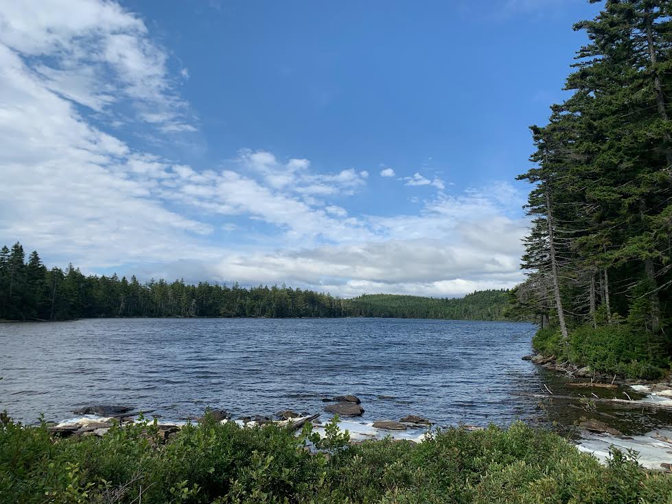
A stiff wind blows out of the northwest, raising whitecaps on the pond, and stirring up white foam on the windward shore. The sun shines brightly and sparkles on the white caps. High fir and spruce along the shoreline wave in the wind. To the south I spy the heights of Beaver Mountain. Quite the sight!
The red-blazed trail ends at this end of the pond. Worn paths lead pond-side, one to the northwest, another around the east end of the pond. I explore these briefly, but concentrate my time at the east end, where I find shelter out of the wind, and break out my lunch. This is a classic spot in the Maine woods – remote pond, wave action, bright sky. I sit, watch, listen to the light slap of the waves on the near shore.
I often take a dip in such ponds, but pass on that opportunity today. Although the deepest point of Mountain Pond is listed at 38 feet, the water at this near end is shallow, and the bottom is marked with rocks and tree limbs. If I were to consider getting wet here I would want sturdy water shoes to protect my feet, and to provide grip. I linger, waterside, taking in the view, feeling the wind on my face.
Turnaround time! What a fine hike, – just enough of a workout, a pristine setting, bright sun, stirring wind. I ascend the pitch of the short hill I descended a half-hour earlier, to begin the 1.5-mile return hike – most of the way now downhill!
With the foliage change arriving, it is time to plan for those fall hikes! Some of the finest hiking weather of the year is with us in September. The Mountain Pond Trail is a good choice for a snowshoe hike when that season arrives! Where are you headed for your next foliage hike?
Trail Notes
Looking for others with whom to hike, or paddle, or head out on a mountain bike trip? The Rangeley Area Trails Coalition (TRAC) is an organization for those who enjoy people-powered activity in the Rangeley Region – and who also like to give back to the outdoor community by volunteering to help with clearing brush, freshening trail markers, and other routine trail maintenance – proverbial “labors of love.”
TRAC schedules day outings year round. Newcomers are welcome. Their Facebook page provides details: https://www.facebook.com/TrailsforRangeleyAreaCoalition/. You may also contact the Rangeley Lakes Chamber of Commerce to be put on their “eblast” mailing list and thereby receive a link to the TRAC schedule under “current events”.
See you on the trail – or on the water!
