


Burnt Mountain in Carrabassett Valley has become one of my favorite hikes. This 3609’ peak sports an above-tree line summit, with outstanding views of the northwestern Maine high peaks – Mt. Abraham, Spaulding, the Bigelows and Crockers, and Sugarloaf. On clear days, I catch a glimpse of Katahdin to the far north. A hot-tub sized rocky pool in trailside Brackett Brook for cooling off at the end of a warm day, adds to the attraction of this 5.8 mile round trip outing.
Although higher in elevation than well-known peaks in the region such as Mt. Blue, Tumbledown, and the Jacksons, in Weld; and both Cranberry Peak and Little Bigelow in the Bigelow Range, Burnt Mountain is curiously less frequently visited than these other hiking destinations. Burnt Mountain is well known to hikers from the Carrabassett area, but perhaps is thought of by others as primarily a skiing locale. The trailhead is located well away from a main highway, which may also be a factor, but that starting point is readily accessed from Sugarloaf Village. After making my first ascent a dozen years ago, I now return once or twice a year.

Getting to the Trailhead
The well-signed trailhead is located at the end of the Bigelow Mountain Road, an short access road to a cluster of condominiums, about 0.4 mile east of the Sugarloaf Hotel and Sugarloaf Village. From Maine Highway 27, I drive the Sugarloaf Access Road to the broad parking lots immediately south of the hotel, and park in the vicinity of the Richard Bell Memorial Chapel. I walk up one set of metal stairs to the maintenance road which heads east, and follow this road – hotel on my right – as it curves by the hotel, passes under a chair lift line and past Gondola Village and the child care area, to become Adamstown Road.
Continuing east on Adamstown Road, I cross the north-south running Mountainside Road and enter Bigelow Mountain Road. At the far east end of this road a blue and orange Burnt Mountain Trail sign on a white birch tree directs the way to a broad Nordic ski trail that also serves as a mountain bike trail. In 50 yards this multi-signed trail crosses Brackett Brook over a planked bridge. The Burnt Mountain Trail is an immediate right, marked by another trail sign and blue paint blazes on trailside trees. I am in the woods now, not a building in sight. Let the mountain hiking begin!
Brackett Brook
I hike through classic mixed growth Maine woods – rock maple, white and yellow birch; balsam fir – parallel to rattling Brackett Brook to my right. The trail is well worn and straightforward to follow, with only gradual elevation gain at this point. At times the brook is quite close; at others it is just out of sight. Painted Trillium and Blue Bead Lily are among the trailside wildflowers on this day. Shafts of morning sun drop down through the forest canopy, throwing fresh light on the forest floor. Quite the sight.
In 20 minutes I arrive at a large boulder where a scramble route skirts the boulder to the left, and the main trail crosses the brook to the right by rock step. A large tree, evidently borne downstream by spring runoff, lies in the streambed – another sign that I am at the crossing point. A blue paint blaze on a tree across the brook indicates the way. Trekking poles are a standard part of my hiking gear for situations like this, as stream rocks can be slippery, or even roll under my feet. The poles save me from wet feet – or even a rolled ankle.
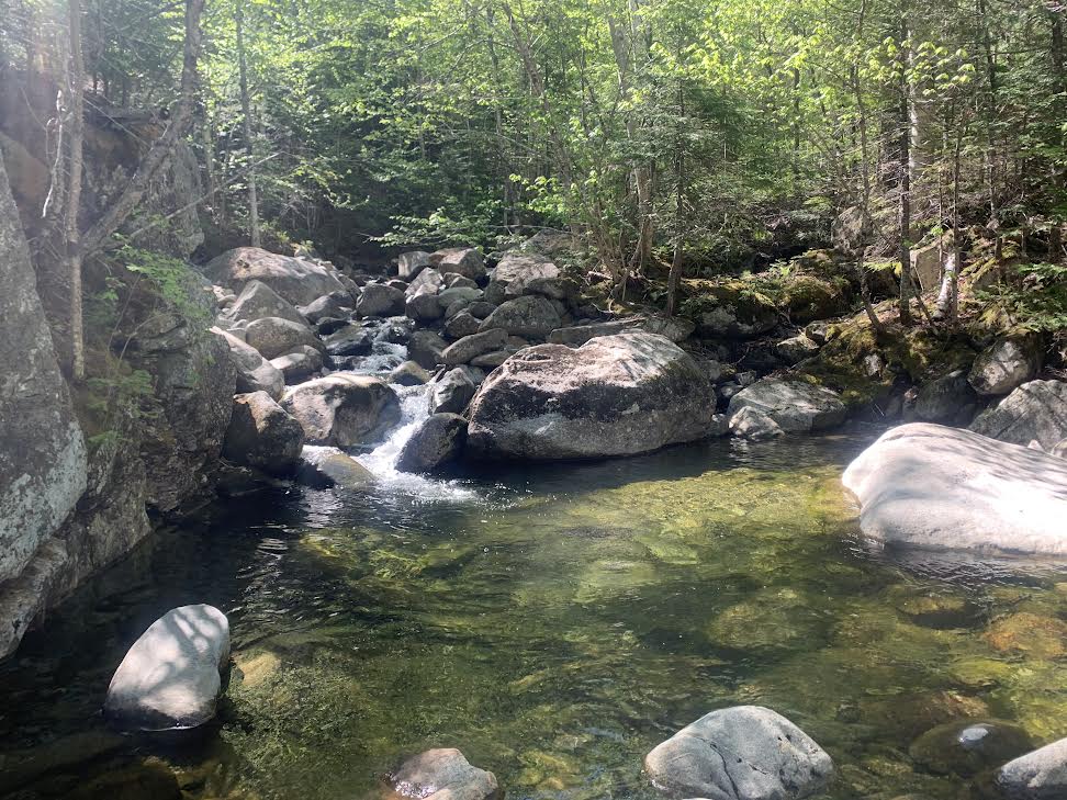
The rockway passes an 8’ long pool that for much of the summer stands waist deep. Tempting! I shall keep that in mind for my return! A dip in cold mountain water would be a fine way to celebrate reaching the final mile of my round trip hike.
Now on the west side of the stream, I continue for another 20 yards before the trail crosses again. This crossing, too, is by rock step. (When I hike in high water circumstances, I have followed the scramble route mentioned above, which holds to the east shore and requires no brook crossing.) Now I am back on the east side of the book once more.
More pools and mini-cascades are to come, as I ascend more steadily now. This is a particularly beautiful section of trail – clear waters of the brook, sharply blue sky overhead, deep greens of the forest canopy, trailside moss, hobble bush, and the like. Most Maine hiking trials have at least a bit of mud, and so I encounter that, too, but not so much that I cannot step over it or carefully step from drier spot to drier spot to pass through it.

On the Ascent
I reach a broad ski trail used to carry skiers by tracked vehicle to the heights of Burnt Mountain for glade skiing. Sugarloaf Ski Area has prepared this section of the ski trail complex for this particular form of skiing by removing some, but not all, trees, to create glades – open areas on the mountain slope that retain some of the standing trees. The slopes receive no machine-made snow, and there are no ski lifts such as chair lift or T-bar. Skiers negotiate their way down the mountain through these glades, charting courses around and through tree stands. It is a demanding and exhilarating way to ski!
Although the bowl between Burnt Mountain and Sugarloaf gathers snow to great depth, the snows are long gone on this summer day. Burnt Mountain Trail signs direct me across the ski trail and back into the woods, and again along Brackett Brook. Eventually the trail swings away from the brook, and turns more directly east, to gain elevation more deliberately. There are occasional sections where the route slabs across the slope to avoid steep terrain, before returning to its easterly line. In these slab sections, among stands of white birch, breaks in the trees offer first views of Avery and West Peak in the Bigelow Range, and of the nearby Sugarloaf summit.
The route becomes steeper still, and balsam fir predominate along the route, as I gain elevation. Finally I break out of the woods into low growth that marks tree line, and reach the rocky, open ground of the col between Sugarloaf and the Burnt Mountain summit. Whoa, such a view – and I am not yet at the very top!
Sugarloaf, Maine’s third highest peak at 4250’ looms large to command the western horizon. (Only Katahdin, 5268’ and Hamlin Peak, 4756’, exceed it.) To the south, Spaulding, another 4000’ footer, at 4010’, rises in cone-shape in a perspective not gained from other vantage points. Mt. Abraham – Abram to locals – is a great five mile-long mass marked by extensive rock rubble at high elevation, lying to the southeast. Summer sun brightens these rock fields known as felsenmeer, or sea of rock, the most expansive such rock feature in Maine other than on the Katahdin tablelands.

Turn Around?
The Burnt Mountain col is a worthy destination in itself, with its fine views. The high point on the mountain lies 0.5 mile north, a steady ascent over rocky ground. On some occasions I have reached the col to find high wind and sharp cold, and decided that it was in the best interest of my party to make this our turn around point. The trail above is over completely open ground with little or no shelter from imposing weather. At all levels of mountaineering, from simple day hikes to the most technical of high mountain ascents, a common error of judgment occurs when hikers resist turning around when weather conditions, time of day, or weariness in a party, merit doing so.
A cold wind blows, but I am ready for it, even in summer. My gear includes a down sweater and a wind and rain blocking shell jacket, wool cap, and gloves. I have ample time, and plenty of water and food. On to the summit.

The Top!
Cairns (rock piled in a cone shape) mark the way, along with blue blazes
painted on rock. Up I go, passing wild blueberry bushes that will yield fruit later in the season, and many an outcropping of high elevation sedge. Various signs and long-strung ropes indicate the out-of-bounds areas for skier purposes. (One would not want to make a wrong turn on skis up here and end up in the thick scrub of the remote valleys that lie to the east and south.)
I ascend to a false peak, spy the high cairn of the true summit a quarter mile off, and continue my climb. With each step I gain more and more of a view. Kingfield, Vose Mountain, the New Vineyard Mountains, the Strong Mountains; Bald Mountain and Saddleback Wind south of Weld; the Crockers to the northwest. When I reach the top, a bit more than two hours from the time I started. The world all but falls away at my feet. To the north lie yet more rugged peaks – Moxie Bald, the Barren-Chairback Range, and the faint, but distinctive profile of Katahdin.
Time to eat and to drink water. I do stop every 90 minutes on hikes to hydrate and eat something to maintain my energy level. Here, at the summit, I linger longer than I do on trail and simply take in that view. For each of the peaks I see I have a story, or multiple stories, from many a hike. Truly, each mountain is different on each hike I take. I do not tire of any of them – the season, the weather, the wild flowers, and wildlife, always different in some way. There is always a discovery to be made.
A caution. Blue blazes continue on the rocks northward, marking a little-used route that connects to the trail system of the Sugarloaf Outdoor Center (SOC). The condition of this trail varies from year to year, and from time to time it has been closed. Blowdowns can render the route impassable. I do not advise traveling that way without consulting the SOC.
Turf and Surf
I begin the descent, now with Sugarloaf, Spaulding, and Abraham massive in the view ahead. In the valley between Burnt and Mt. Abraham rise two lower peaks, Blackk Nubble and Owls Head. In an previous summer I traversed that wild valley on snowmobile trail, seeing not a single other hiker. After passing through the col and re-entering the woods, I meet two other hikers in succession. Down, down, I go, eventually to reach Brackett Brook, and the stream crossing with the wide pool.
The bottom of the pool is filled with small stones, how sharp I do not know, but on one hike in recent years I stepped into a similar pool and cut my foot in so a serious a way to require stitches. I carry a cheap form of water shoes – an extra pair of socks. These are standard in my daypack. I slip into the pool wearing my quick-drying hiking shorts and the socks that have cradled my feet all day. I will change into fresh ones following my dip. Towel? A bandana works fine for that purpose – that and the summer sun.
Cold! But oh, so good! I sit on the bottom, water up to my neck, plunge my head in all the way. Life is good. A swim pool, a surf beach, or Tumbledown Pond, this is not – simply a clear pool in a mountain brook just big enough to sit down. Who knows what the water level will be should you come this way? But pack a spare pair of socks, just in case.
I hike the remaining distance, return to my truck and head for home, pulling over south of Kingfield for a look back at Burnt Mountain, Its long dark green ridge slopes outward and upward from its sharply-peaked neighbor. Sugarloaf. There are higher summits than Burnt Mountain in the region, but only a few match its striking view. Happy trails!
