The first significant snowfall of winter, with over a foot and a half lying in the woods and fields by our farmhouse, provides all the prompting I need to head for my first mountain ascent of the season. My destination is 2386’ Bald Mountain, south of Weld and north of Wilton, off Maine Highway 156, in Washington Township. I hike this peak two or three times per year, to enjoy a dramatic view that includes the Presidential Range in New Hampshire, a half-dozen of Western Maine’s high peaks, and, of course the peaks of the nearby Tumbledown and Mt. Blue Ranges.
Although Bald Mountain is of modest elevation, it rises sharply from the surrounding terrain, gaining an attention-grabbing 1400’ from trailhead to summit, over an estimated 1.4 miles, one way. The exposed ledges on its high ground, which give the mountain its name, provide the feel of peaks much higher in elevation. Here I find stunted fir, spruce, pine, and birch common to above-treeline locales, along with the shrubbery of mountain cranberry and wild blueberry.
Popular in the warm months, Bald is also frequent choice of winter hikers. I see hiker vehicles parked at the Maine Highway 156 trailhead in every month of the year. Of all the Weld region peaks, Bald is the only one with a trailhead on a paved highway. Highway crews thoughtfully push back the snow along the roadside to allow space for winter parking.
The trailhead is marked by a prominent sign, brown with red lettering, on the west side of the road, about 8 miles north of the junction of Route 156 and Main Street in Wilton, and 5 miles south of the village crossroads in the center of Weld. This point is 0.1 mile south of the Perkins Plantation highway sign, for those traveling south from Weld Village.
For north-bounders, heading from Wilton, cross the Perkins line, and you have just passed the trailhead by that 0.1 mile.
Snowshoes or No Snowshoes?
Let’s hike! The first question of the day is whether to wear snowshoes. On every winter hike I carry both snowshoes – which have built-in crampons – and flexible boot crampons (aka “Micro-Spikes”) for use on ice and slick crusted snow. Conditions at the base of a mountain can be expected to differ from those at higher elevation. Winds may sculpt deep drifts on high ground Those same high winds may blow snow clear from ledges, leaving a thin layer of the white stuff to thaw and freeze, forming ice too slick for a hiking boot or even snowshoes to gain a grip. No point in reaching near the top only to be stopped by a surface too slick to proceed. Another standard piece of my winter gear is a set of adjustable-length trekking poles equipped with snow baskets.
I start with snowshoes, and am glad I did. In 50’ I reach Wilson Stream, about 16’ wide, running fast around scattered snow-covered rocks. Snow bridges reach from rock to rock, cold and clear water racing underneath. How firm are those bridges? They appear simply as mounds of soft snow. There are tracks from those who have hiked here in recent days. These are ominous signs, as there are places where the snow bridges gave way, and the tracks lead into the water. Not my preferred way to start the hike! Using trekking poles to test the bridges, and for balance; and snowshoes to distribute my weight, I make my way across successfully. On other winter hikes here, I have explored upstream and down for a more favorable crossing point if I do not like what I see.
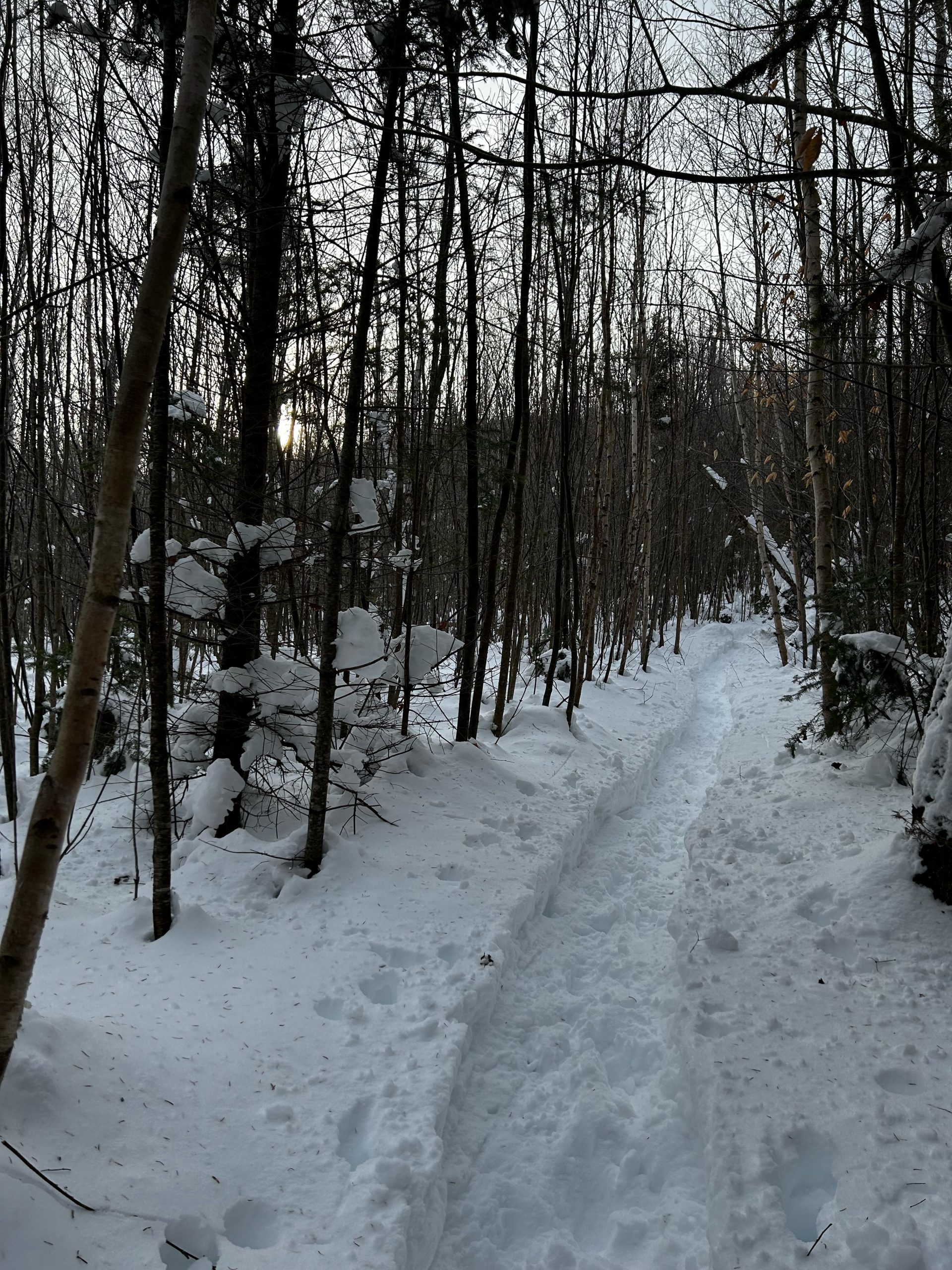
A register box stands 20’ beyond the stream, to the right of the trail. I sign in, noting the time of day, and my intent to reach the summit. From this point the blue-blazed pathway ascends westward steadily in a straight line, through young hardwoods about 10 years old. Rock maple and white birch, 2-3 inches in diameter, reach some 30’ towards the sky. In summer these shade the trail, and in fall they all but encircle hikers with hues of bright yellow gold, orange, and scarlet.
The trail has been broken out by previous parties on snowshoes, but the snow is deep and remains soft and loose in the footpath. I keep my snowshoes on to avoid frequent slippage and foot roll, which can be very fatiguing. My snowshoes provide good grip over the steep ascent. Progress is slow, but sure – which is what matters. I warm from the effort, stop to remove a clothing layer to limit perspiration.

Hardwoods to Softwoods
I scramble up and around a set of boulders, and the surrounding forest transitions from those slender rock maple and white birch to conifers – mostly balsam fir and red spruce, with an occasional white pine. The setting becomes “story book”: evergreen branches droop, heavy with thick snow, the dark hunter green shade contrasting with deep snow cover, bright white even on this cloudy day. Soon, trail signs announce “The Step – I” and “Alt. Route”. I know the first to be a steep scramble with marginal toe holds – often my choice while on a summer hike in dry conditions.
The alternate route is my choice today. Fairly deep in snow, and still steep, this route moves up a cleft in the rock, which I find to be more manageable than the more precipitous “Step I” route. My snowshoes and trekking poles help here. Both routes join at the rounded edge of a set of ledges where ice commonly accumulates under the snow. Do I remove the snowshoes here and put on flexible crampons? I test the grip of my snowshoes – which do have built-in serrated edge snowshoe crampons. They hold. I scramble up and over the edge, straighten up, and enjoy my first long view of the day.
Ledge Views
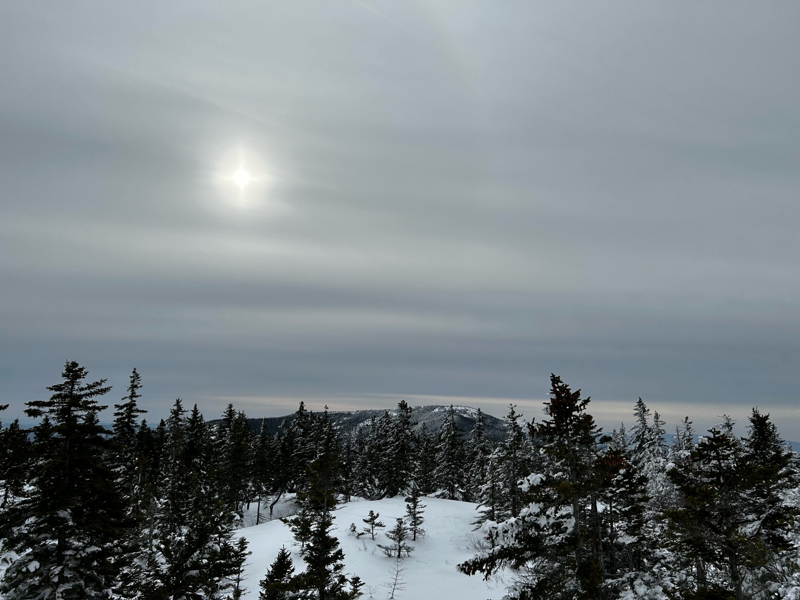
Mt. Blue rises to the northeast, its summit tower prominent. Little Blue rises beyond; Center Hill near its base; the mountains of Temple mountains more easterly, and the New Vineyard Mountains farther yet beyond these. The sky is a milky white and gray. Cloud cover hovers just above distant Saddleback Range. I note a rising wind – out of the northeast. Change is in the air. The sun is a hazy white orb peeking through the clouds, slipping from sight, returning.
I continue upward on the ledge, enter a stand of conifers, emerge again onto more ledge. I follow the line of snowshoe tracks, but to avoid repeating someone else’s errors, I keep watch for trail blazes – which appear on trees, and on exposed rocks, and in the form of cairns piled up to 3’ high. As expected, the wind has stripped some sections of ledge clear of snow. Elsewhere, I step into drifts of soft powder where I sink early to my knees. Slow is the going, but sure.
Soon I reach “The Step – II” and its “Alt Route”. I know this step to run up a steep pitch through a cleft in the rock, a tighter space for snowshoes than my just-completed ascent to the first ledge. “Alt Route” it will be, challenging enough as the wind has largely obliterated the snowshoe track above me. On the watch for cairns, I ascend a high-rising shoulder of the high ground. spy one cairn, then another, and even a stripe of blue paint on wind-blown ledge. Up I go!
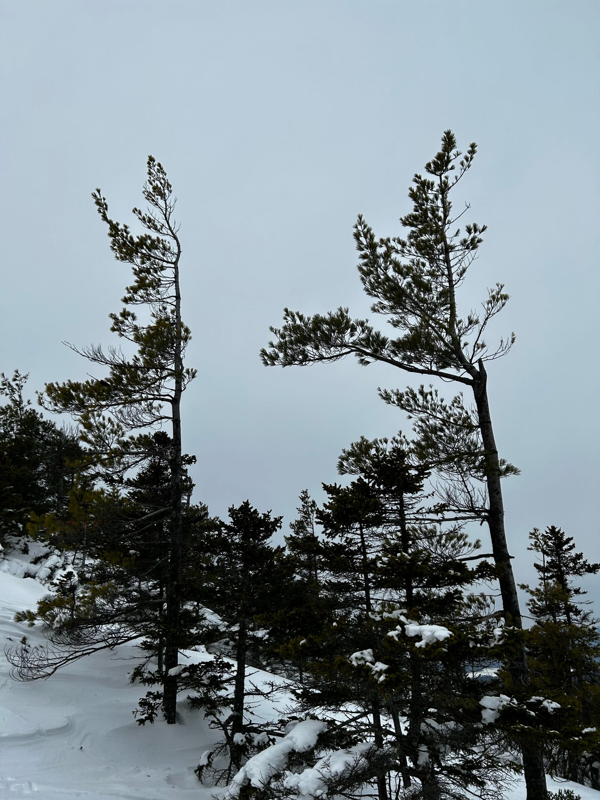
Trees on this exposed section provide evidence of the powerful force of the wind. Two pitch pine, rooted in seed flung high on the mountain by prevailing north-sourced gales, stand with branches that extend only on one side. – to the southwest. Such are called “flag trees”. They extend no branches northward, only southward, not fighting the wind, but aligning their growth with its flow.
White birch, a slender tree elsewhere in much of the Maine Woods, in this harsh environment grow as shrubs, low, multi-branched, with a hint of copper to their color. Black spruce and balsam fir, referred to as “scrub” in such settings, grow stunted, most under five feet tall.
I see no other hikers, hear no sound but the wind. Ah! A sign of life! Tracks of a snowshoe hare cross the snowpack from one stand of scrub to another, from north to south. Surely this particular hare is tucked well in out of the wind, in anticipation of the storm to come. I study the sky, note that the barometer is falling, and that the wind has increased. Snow will fall in earnest in a matter of hours. I have established a turn-around time, and am well within that time frame.
My direction is westward. Now close by the summit I have a fine view of Saddleback Wind, a peak that is a near twin to Bald Mountain. This Saddleback, also known as Saddleback Wind, to differentiate it from Saddleback Mountain near Rangeley, is a worthy hike with views equal to those of Bald, but the trail linking the two is currently closed. There is a trail from the Carthage side to the west, in the vicinity of the wind farm located on Saddleback Ridge, but I have not yet hiked that route and do not have personal information about that trail.

The Summit
My route to the summit of Bald Mountain takes a northward turn. I skirt a tree-lined depression, remnant of a small high mountain bog, which I know can hold deep snow and is to be avoided. Finally, I reach the last of the collection of high-rising ledges, scramble to the highest point. I am at the summit.
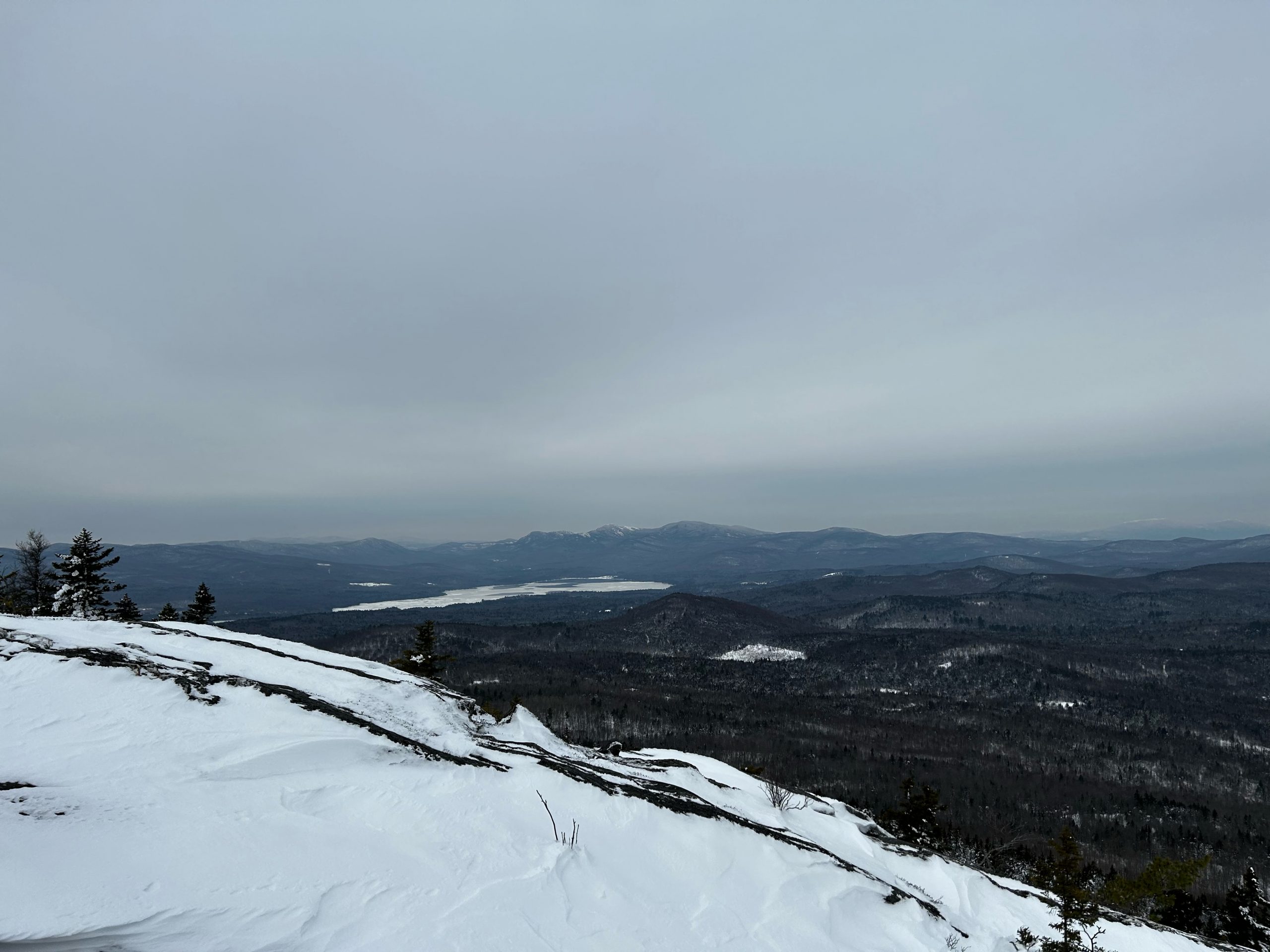
Webb Lake lies to the north, a rough triangle standing on its long point, where the Webb River flows southward out of the lake to meet the Androscoggin River at Dixfield. There is open water at the north end. Central and southern expanses of the lake are white with frail ice and wind-blown snow. (Ice-fishing enthusiasts take notice. On this day near the first of the year, this lake is far from frozen over.) Snow-topped peaks rise in every direction. New Hampshire’s high peaks are hidden in the clouds, but Mt. Abraham (Abram), The Saddleback and The Horn near Rangeley, and Old Speck to the west, extend to just under the cloud ceiling.
I pull out a square of closed cell pad for sitting on snow, pull on a hooded down parka I had stuffed in my pack, break out a thermos of hot soup. The wind rises and falls. Silence prevails. I sit and do nothing but look out, scan the horizon, watch for movement – perhaps a junco or even that hare. I notice the variations in layer-cake clouds, the different shades of gray, a tiny gap here and there revealing a patch of blue. As is my custom, I listen for changes in the sound of the wind, as it ebbs and flows, and the tiny sound made by scatterings of snow blown from the nearby scrub, onto the ledge where I sit. Quite a time.
A chill stirs me. Time to generate some heat. Time to return to the trail. I pack up, head out, head down. The descent is a smooth one, as I have packed the trail well on the way up. Reaching the summit over soft snow, with careful negotiation of slippery spots, required over two hours. On the way down, I arrive at the roadside trailhead in 45 minutes.
The Weld Valley with its lake of remarkable beauty, encircling mountains, and views to some of the highest peaks in Northern New England, is surely one of the most compelling outdoor settings to be found anywhere. What are your winter plans for exploring the Maine mountains by foot? I hope to see you on trail!

Winter Hiking Tips
Plan for limited hours of daylight: Allow extra time for winter hikes by starting early in the day. Set a “turn-around time” that returns you to the trailhead at least one hour before sunset. If the sun sets at 4:00 p.m., the goal is 3:00 p.m. If the hike starts at 8:00 a.m., 7 hours are available. Divide that in half, to obtain the turn-around time, 3.5 hours on trail, or 11:30 a.m.
Stick to the time. A turned ankle or other injury will slow the hiking party. Some trails become more difficult on the descent. Be aware that trails on the east side of a mountain lose daylight sooner than those which lie in the direction of the setting sun.
Aways carry a headlamp, with extra batteries – one for each member of a party. Hand-held lights are nearly useless, as hikers will need both hands free for a descent.
Select clothing for “Go” and for “Stop”: Exercising, even in cold weather, generates heat and can lead to perspiring. When a hiker stops, that perspiration may cool the body quickly, which is a forerunner to hypothermia.
Wear wicking clothing, such as wool or synthetic wicking material (not cotton) next to the skin. Dress in layers that can be removed as a hiker warms, and put back on when the weather – or the hiker cools. I always carry a hooded down jacket in my day pack, and put it on when I stop for a lunch break, extended photo shoot, or one of my sit-and-observe times. Care for feet, hands, and head, with winter hiking shoes, mitts with wool liners, and a wool or fleece cap and neck gaiter. Those parts of the body are susceptible to chilling, and much discomfort. Take good care of them.
Drink and eat: Instead of restricting intake to a single middle-of-the day lunch stop, drink water at least once per hour, and eat no less frequently than every two hours – whether feeling thirsty and hungry or not. The body works extremely hard in winter to keep warm. Hydrating and eating regularly are essential to maintain energy, and to avoid hypothermia. I like to bake my own “power bars” and pack a hearty soup in an insulated container. Enjoy the food and the hike!
Traction: Metal snowshoes with built-in crampons are widely available. These work well on surfaces both slick and not, and reduce slippage on uphill travel. However, they can be cumbersome, and even ineffective, on steep terrain. I carry spiked flexible boot crampons on all winter hikes, changing into them for particularly slick terrain when my snowshoes are not effective. For the highest ground, or especially steeply angled terrain, I use platform crampons, which are designed to be worn with stiff winter boots, and consist of a spiked flat and firm metal grid, which is strapped to each boot.
Ice creepers are usually not suitable for hiking. They are designed to provide traction on level surfaces such as sidewalks and driveways, not on angled terrain. Besides being ineffective for the traction commonly needed for hiking, they may fall off in snow of even moderate depth, or when the foot rolls or slips. I find these in the snow on many hikes! To those shopping for traction devices, I urge consulting with someone who is familiar with winter mountain hiking. Having proper gear is a vital part of a successful outing in the Maine Mountains.
Text and photos copyright 2023
Douglas Allan Dunlap