


Forest Legacy Trails is a 1272-acre tract of land on the west shore of Cupsuptic and Mooselookmeguntic Lakes, in Adamstown Township, west of Rangeley. Managed by the Rangeley Lakes Heritage Trust (RLHT), Forest Legacy offers nine miles of hiking trails, and five lakeside campsites. I have long wanted to explore this trail system and spend an overnight at one of those sites, and finally do so in this summer of 2022.
Although the trail system is open to the hiking public at no cost, camping for hikers or boaters is restricted to designated campsites and requires both a reservation and payment of a fee in advance. Each of the five sites is limited to one camping party only. All such reservations are made through Cupsuptic Lake Park and Campground (CLPC) located on Maine Highway 16, 4.3 miles north and west of Oquossoc (cupsupticcampground.com; 207-864-5912).
I am up for a good hike in the Maine woods – why not pack overnight gear, take my time, and enjoy a summer night tenting lakeside? This plan would allow ample time to explore most of the trail network, with no rush to be out of the woods by nightfall. I give the friendly people at the Campground a call, reserve the Smudge Cove campsite on Cupsuptic Lake, and prepare for two days in the Forest Legacy tract.
Getting There
The Forest Legacy Trailhead is at the end of 0.5 mile Mud Pond Road, off Maine Highway 16, five miles west of the Cupsuptic Campground, and 4.5 miles west of the highway bridge over the Cupsuptic River. Look for a sign 0.3 miles before the left turn (south) to Mud Pond Road, and another sign, brown with orange lettering “Forest Legacy” at the turn itself. This gravel road ends at a parking area, gate, and a kiosk displaying a map of the trail system.
My standard procedure is to carry a paper map on all my hikes. I pick two up at the Cupsuptic Campground on my way to the trail – one with contour lines, one without but providing information about the history of the tract, and about land use here. If I had neglected to do that, I could take a photo of the kiosk map with my phone. As it is, I take a photo anyway. If I should lose the map, or if I encounter hikers who do not know where they are, and have no map this provides me with an extra map to share. (I have encountered both circumstances when I am on trail) I now have a backup map on my phone – and I carry a spare phone battery in my pack.
Skyline Trail to Mooselookmeguntic Lake
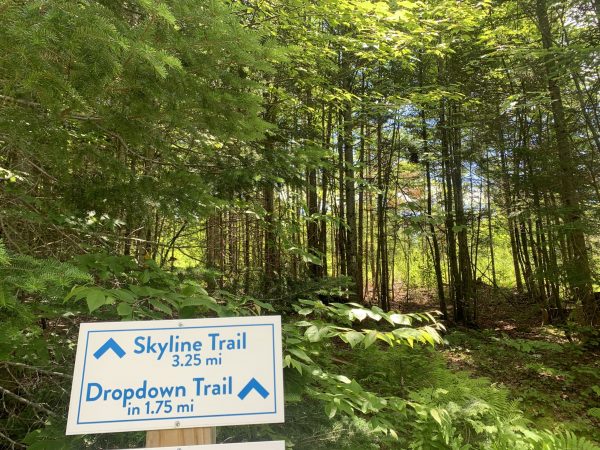
I find the paper map to be handy from the very start, because the first section of my itinerary – hiking the Skyline Trail 3.25 miles along the southern boundary of the Forest Legacy Trail all the way to the shore of Mooselookmeguntic Lake has a separate starting point from Skid Road, the other major route to the lakes. The Skyline trailhead is 30 yards back on the Mud Pond Road, just before the parking area. A sign marks the spot where the trail enters the woods on a southward course, following the southern boundary. As the name implies, the trail traverses high ground on the tract before descending to the lakeshore.
Skyline Trail is also the starting point for hikers who plan to take the Drop Down Trail. Drop Down diverges from Skyline in 1.75 miles on Skyline Trail, to reach Cedar Bay on Mooselookmeguntic Lake after an additional 1.0 miles. This route is a steady descent. I do not hike on Drop Down on today’s hike, opting to explore Skyline Trail over its entire length to the lake. Another descending trail, Lost Saw, appears on one of my two maps, but not the other, as descending from a trail junction only a quarter mile above Mud Pond. I see the overgrown pathway, but no sign, and conclude that it has been discontinued.
There are blazes galore on Skyline – bright yellow to mark the boundary of the Forest Legacy property, and white to mark the trail. This is an important difference! Skyline Trail and the boundary coincide for part of the way, diverge, rejoin, and diverge again a number of times. Follow the white paint!
Skyline is a woods walk for the nearly all of its length, except for two locations where the trail crosses low ridges and offers partial views through conifer forest towards Mooselookmeguntic Lake. It begins with moderate ascent through rock maple, white birch, and other hardwoods, drops into a broad draw, climbs again, skirts ledge outcrops, and continues this up and down pattern over most of the first 2.5 miles. At 1.75 miles Drop Down Trail diverges left (east) towards Cedar Bay campsite. Surprise! A ruffed grouse – a “partridge” locally – explodes out of the underbrush – bursts off into thicker growth. That gets my heart rate up!
Eventually I reach one of the higher sections of the trail, a stand of red spruce with enough open space under the canopy that I enjoy a view through the trees of both Mooselookmeguntic Lake, and the ridge line of long east-west running, multi-peaked, Bemis Mountain, on the southern horizon. The process repeats, as Skyline drops into a shallow col, before rising to another view southward, this time through a stand of balsam fir, 14-16” inches in diameter.
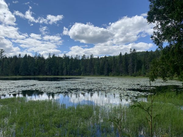
In the last mile of Skyline Trail I descend into a boggy area where moss-covered bog bridges – cedar logs ripped lengthwise and spiked end to end into cross beams – mark the way. I wear hiking shoes with good grip. In wet conditions these bridges could be slippery. Mud Pond itself is reached by a 20 yard spur trail. Water lilies are in full bloom on the day of my hike – a sea of yellow flower – and quite the sight. A few steps more bring me to a boat dock at the extreme southern end of the Forest Legacy property.
Shoreline Trail
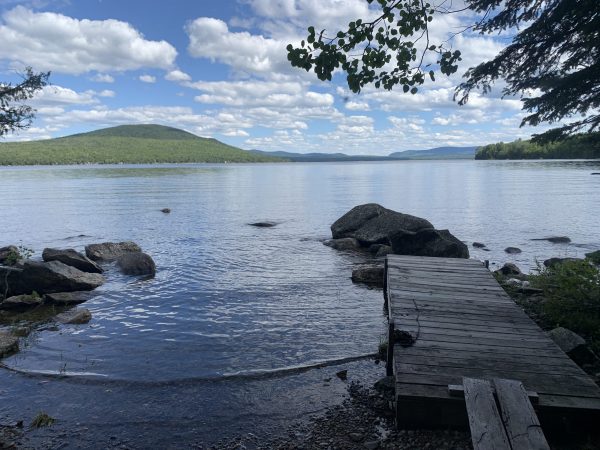
The boat dock is by the intersection with Shoreline Trail, which next I follow northward for 3.5 miles to each my evening’s campsite at Smudge Cove. Over most of this length the trail passes within view of, first, Mooselookmeguntic Lake, and then Cupsuptic Lake, passing short spur trails to all five waterside tent sites.
In 0.4 miles I reach Eagle Cove campsite, where I enjoy a fine view across the water to Bald Mountain in Oquossoc. From this angle, Bald has a distinct high-rising domed shape. This now-popular hiking peak was the original alpine ski mountain in Rangeley, before Saddleback Mountain was developed. Now the former ski trails on Bald Mountain have grown back. Most of the mountain is in Maine Public Reserved Land. A 1.3 mile hiking trail leads from a trailhead on Bald Mountain Road to an observation tower on the summit. Views are striking – the many expansive lakes in the Rangeley Lakes Chain, Mt. Washington, the Saddleback Range, border mountains on the southern rim of Quebec.
Next stopping point on the Shoreline Trail is Cedar Bay, also on Mooselookmeguntic Lake, and where the Drop Down Trail enters from the west. I continue northward, cutting across the Eagle Point peninsula, which is private land, and not part of Forest Legacy lands. The peninsula effectively divides Mooselookmeguntic Lake to the south from Cupsuptic Lake to the north.
Once these were two separate bodies of water, connected by a thoroughfare. When Upper Dam was constructed between Mooselookmeguntic and Richardson Lakes, the resulting rise in water level joined the two lakes as one continuous body of water – the status now.
As I cross the peninsula, out of sight of the shore, I pass a small beaver pond to the left of the trail – so small that I nearly miss it. This tiny wetland is full of life – cattails, ferns, bog grass. Skid Road trail junction as next, which connects Shoreline Trail to the Forest Legacy trailhead and parking lot. This is a logging road, now grown over with grass, but straightforward to follow, and fairly easy walking underfoot. I continue in a northwest direction on the Shoreline Trail.
Five minutes of walking brings me to Cold Brook campsite spur trail on the southwest corner of Cupsuptic Lake. I take the short walk to inspect the site as one I might choose for a future trip. Bald Mountain is out of sight from Cold Brook, but there is a different view to be had here, every bit as striking as Bald Mountain. The pyramid peak of West Kennebago Mountain, a former fire tower peak, commands the northern horizon. I have hiked to that summit many times, in warm months and in winter. The next time I do so I will be on watch for Cold Brook and the other sites on Cupsuptic Lake west shore.
Wild Landscape
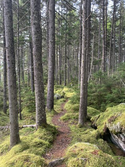
For the remaining 1.5 miles of my hike I pass through forest of remarkable beauty – glacial erratic boulders, irregular rock slabs, moss-draped forest floor, red spruce and balsam fir, rock maple and moose maple. Though the trail runs one hundred feet inland from the water, I have good views of the lake through the understory. Here and there blowdowns – indication of high north winds that batter this shoreline from time to time, cross the trail. I climb over some, walk around others – all quite manageable.
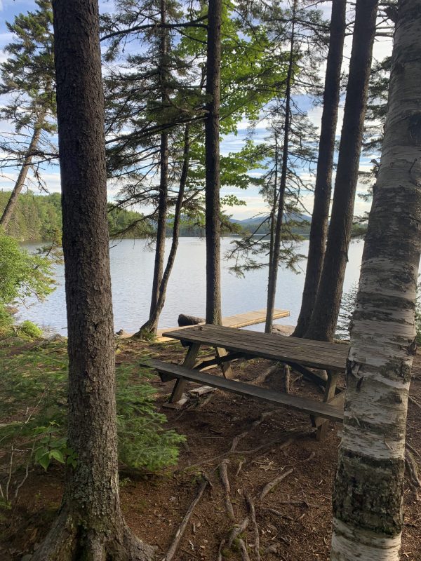
At a four-way intersection, the Timberland Trail enters from the west – a route to access the trailhead and parking area on Mud Pond Road. To the east, Timberland Trail continues to Raven campsite on Cupsuptic Lake. I skip an inspection of the Raven site, because I was informed that it is occupied. Straight northwest lies my destination, Smudge Cove, 1.1 miles to go, where the Shoreline Trail ends. More moss, jumbles of rock, and a seasonal brook; some elevation gain and loss to cross a low ridge that separates the cove by Raven site from the cove at Smudge – and I reach home for the night. Along the way I spy moose scat, and that which I take to be of a fox or fisher – if not a coyote.
In Camp
Now in camp, I set up my one-person tent; roll out my sleeping bag; unpack and fluff my sleeping bag. Next I set up the camp kitchen, simple enough, as it consists of a single titanium pot, a cup, a backpack stove the size of my thumb, and a fork-spoon combination. My supper, the makings of a double-portion hearty vegetarian stew, with whole-wheat biscuits and homemade raspberry jam, remains in a food bag I suspend from a branch. Last, I organize the remainder of my gear – what little there is – in logical piles in the tent: spare clothing layers; book, journal, spare batteries, and headlamp; first aid supplies. If I planned on a fire I would gather firewood at this time, but the evening will be a warm one, and is pleasant enough as the lowering sun casts a gold sheen on the east shore of Cupsuptic Lake. This site does come with a fire permit.
Camp set up, I step to the lake, and into it! A dip in brisk Cupsuptic Lake water water is a pretty good way to refresh after seven miles of hiking. Does that water feel good! I follow that dip with that supper of hot stew and biscuits. After clean up, I jot down notes from the day, and follow that by sitting at the picnic table to watch the light change on West Kennebago Mountain as night falls, listen for the call of loons in the lake. I wait, watch, listen, in no hurry whatsoever. The gentle lap of lake water on the rocky shore, is the only sound to break the great, broad silence of the evening – that and the calls of loons.
To the sleeping bag!
Pre-Dawn Awakening
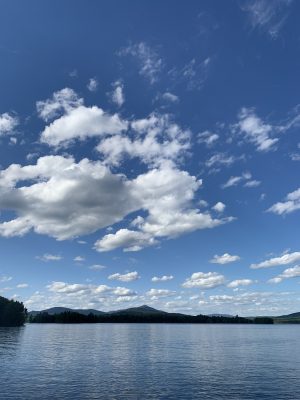
I awake before sunrise to a lightening sky in the east – hues of rose and orange, sky turning from gray to blue, a few streaks of clouds white with gold edges from the light of the sun I am yet to see. Oatmeal, and a homemade Morning Glory muffin I packed in, constitute breakfast. Trout make rings in still waters only a few feet from where I sit on a rock looking out across the lake. The sun touches the heights of West Kennebago – gold on those hills, if not in them. A great quiet abides.
An admiral butterfly arrives, flits about my campsite, flies on. I step into the nearby woods for a close look at great swaths of moss covered boulders and logs. A small fir has taken root in the moss atop one refrigerator-sized boulder. Quite the sight!
Time to move out, to take the first steps that will lead toward home. The distance I cover to return to the trailhead and my truck is less than half that of yesterday’s hike. I will walk Shoreline Trail South to Timberland Trail, and follow that to the upper section of Skid Road. It is all gentle walking, and at the best time of day to be in the woods – the early hours.
What’s next for me and Forest Legacy? I would surely take this hike again. Perhaps I will paddle here by canoe or kayak, as a day trip, or for an overnight. This is a Western Maine Mountains destination to which I do plan to return – perhaps with grandchildren – either by foot, or by paddle.
Deep appreciation goes to the Rangeley Lakes Heritage Trust, and the associated Community Conservation Corps, for their stewardship of Forest Legacy!
Where are you headed for your next journey?
Camping note:
All campsites in the Forest Legacy Lands are by prior reservation and payment only. Contact Cupsuptic Lake Park and Campground to make those arrangements.
Text and photos copyright Douglas Allan Dunlap 2022.
