


On a crisp fall morning, the hardwoods ablaze in red, orange, and gold, I am on trail, on the Fly Rod Crosby Trail northward out of the Reed’s Mill trailhead in Madrid. I am on a trail maintenance trip but the “a labor of love” cliché surely applies. As fall foliage in northern Franklin County approaches peak color, I hike in the midst of it, in the heart of the Maine woods. Today’s hike, much of it along raucous Orbeton Stream, which tumbles and roars down from the high Mt. Abraham and Saddleback Ranges, places me where the bright new colors of the season are right overhead, or at reach-out-and-touch distance from where I walk.
The trail maintenance aspect of this hike amounts to a check of late season trail conditions, pulling fallen tree limbs off the pathway, clipping brush that encroaches on the trail bed, and freshening of trail markers. So doing, I am one of dozens of volunteers who apply similar efforts to hiking trails throughout our Franklin County each year, including this Phillips to Rangeley region Fly Rod Crosby Trail. (Like to get in on the trail volunteer act? Contact highpeaksalliance.org, where there is a volunteer link.)
My destination and turn-around spot is the point where the Fly Rod Crosby Trail reaches the West Bank of Hardy Stream, a tributary to Orbeton Stream flowing down and out of the steep valley between The Horn of Saddleback (4023’) and Saddleback Jr. (3640’). The trail distance is 4.3 miles, one-way from Reed’s Mill, 8.6 miles round trip. Typically, when I hike this round-trip while on a purely recreational outing, I allow 4-5 hours, including breaks. Today, I plan for eight hours, considering frequent stops for the trail work.
The Reed’s Mill trailhead is 4.5 miles east of the Maine Highway 4 junction with Reed’s Mill Road, on the left (north) side of the road in a small field. There is ample space to park. This point is 0.1 mile east of Star Barn, and 0.1 mile west of Reed’s Mill Church. A prominent kiosk displays a large map of the entire Fly Rod Crosby Trail, from Phillips in the south to Oquossoc in the north. There are usually paper maps available in a box with a trail register. If there are no maps left, I advise taking a photo of the map display. My standard is to carry a paper map on every hike I take in the Maine woods, even if I have a map app on my phone.
The trail, marked by blue paint blazes and occasional diamond-shaped symbols, enters the woods behind the kiosk and immediately divides, offering hikers the option of a new one-mile Reed’s Loop, which climbs to high ground well above Orbeton Stream before dropping down to the stream itself to join the main route of the Fly Rod Crosby Trail. This loop offers some views westward through the trees towards the mountains of Weld, more so following leaf drop.
An intriguing feature along the Reeds Loop is a curious stand of red-barked Norway spruce (not Norway pine), planted here in the 1950’s. by a landowner who wanted to create a Black Forest effect. (There is a similar plantation on the Hunter Cove Trail on the north side of Rangeley Lake.) When I first hiked here a dozen years ago, I was stumped (no pun) at what trees these were. Local inquiry rendered in the Black Forest story. The Loop circles back to the trailhead after a stretch along the stream – a fine short hike: ups, downs, views, and a stream.
The main Fly Rod Crosby Trail route is a right turn at the trail divide beyond the trailhead kiosk. This section has been rerouted, and just opened in 2022. This new section of pathway represents a fine choice of route and a high standard for trail construction and marking. Volunteer trail crews have cleared the pathway well, and allowed for good drainage, to keep water off the trail to forestall erosion. Blue-blaze trail markings are fresh and frequent. The route slabs across a slope of mixed hardwood and softwood growth before descending in switchbacks to an old woods road – duff, grass, and leaf covered – that runs parallel to the stream.

The walking on this old roadway is soft underfoot, and the setting serene, with morning sun breaking through gaps in the canopy to scatter light on the footpath. Here I have the first of many close-up views of the dramatic foliage. A beech tree extends a cluster of yellow and amber leaves towards the trail. There is more – much more – color to come on this day’s walk in the woods, a profusion of shades of yellows and gold, red and orange.
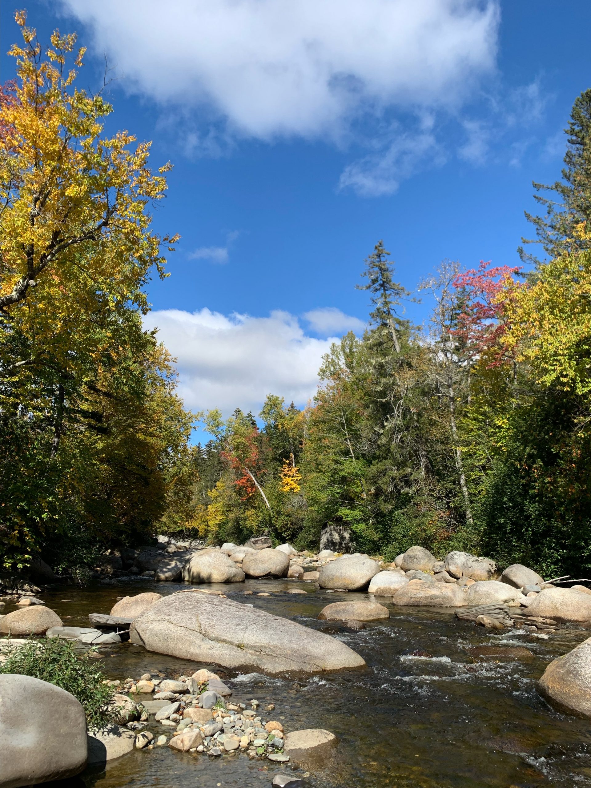
Orbeton rolls by with a roar, 20 feet to my right. I step off trail and push through stream-side alders to stand at the water’s edge. Here, roiling waters race around boulders in various shades of gray, some honed by the waters to graceful smoothness, others holding to angular shapes they have had for time immemorial. Below the boulder set, the stream turns white in a set of rocky rips with a constant sound like that of off-loading gravel.
Front and center in this look at a wild mountain stream in its rush to the distant sea, a red maple extends its limbs stream-ward. The leaves are a bright scarlet. Red maple take their name from the red flowers they display in early spring, but they put on quite a show in this other end of the season, when they go out in a blaze of bright red leaves. Nearby low growth – hobble bush, broad ferns, and moose maple, get into the act, each with its own expression of color, from maroon-shaded red, to all manner of gold. Quite the sight, right by my feet. I enjoy the long view of fall colors from a high peak as much as anyone, but today’s display, up front and personal as it is, makes these moments a gift.
The old road the trail follows merges with a rougher, more recent twitch road, and the hiking route moves away from these roads to become a woods pathway, still well-defined. Here I find the first significant accumulation of blown down branches, surely a result of high winds of recent days. I clear them off the trail. There is trimming to be done, too, as trailside popple (aspen), young maples, and persistent hobble bush extend their growth onto the trail. Out of my pack come the clippers.
The trail switches back and forth between following old road bed and running as a traditional foot way through thick woods. Trail building crews have chosen whichever routing offers the more expedient way over the terrain. My maintenance efforts continue on a day ideal for working outdoors – cool, bright, dry.
I break for lunch, seeking, on this cool day, a perch in warm sunlight close to the swift-running stream. Making a way from the trail to the edge of the stream bank, I step down to a rock and gravel strewn shoreline – and find my spot. Nearly at mid-stream, brightened by full sun, rests a sitting-sized boulder. To reach it, I step from intervening rock to rock, carefully so, using my trekking poles for balance. The water is not deep here, perhaps 1-2 feet, but a slip would surely put part of me, or all of me, in the water. The trekking poles, standard on my hikes, are handy, giving me three points of contact with streambed or rock, rather than just one, as I take each step. I reach the rock, have a seat.
Such a spot! I face downstream, southward, where the slanting-in light of the fall sun sparkles on a stretch of mid-stream ripples. To either side of me, clear water runs short courses around nearby boulders, combines, divides, combines again, races downstream. Dramatic as are the sights of rushing water and sun-lit waves, is the surround-sound – the all-encompassing roar of high-tailing water. I sit smack in the middle of it. Think of it – here runs water flowing off the slopes of the some of the highest elevations to be found in Maine, on its way down the Orbeton Stream Valley, to enter the Sandy River, pour into the Kennebec River, eventually to empty into Merry Meeting Bay, and beyond that the Gulf of Maine and the broad sea.
To what might I compare that sound – the roar of the racing stream over its rocky bed? The breaking of waves along the Maine Coast at Pemaquid Point, Sand Beach, Rogue Bluffs, or the Cutler Coast? Or the rumbling of a Canadian Pacific freight train making its way along the remote stretch of track near Skinner settlement which I heard once while exploring that lightly frequented part of northern Franklin County – a bass tone rising as the train approaches, falling as it disappears from sight into the woods. The sound of wild waters has its own distinct quality, born of full force of swift flow, bounce off of boulders, the raking over rocky bars, the moment-to-moment variations in flowage akin to breathing. Constant, yet different; different yet constant. I have a front row outdoor concert hall seat.
The mid-day sky is sharp azure blue, nearly completely clear, with a single ragged-edged cumulus cloud, bright white, floating at high center. To the east, just above the stream bank towers a great hemlock, which I estimate to be 80’ high. Sunlight on the yard-wide trunk brings out the reddish hue of the rough brown bark. The crown and lengthy limbs, needles a rich, deep green, sway in a strong breeze. On the downstream side of the hemlock stands a thick yellow birch, nearly as tall as the hemlock, its foliage the color of gold patina. On the other side rises a red maple, with a curious display of individual leaves part red, part bright yellow. Quite the show! Streamside alders shake, their green leaves turning over in the downstream-headed wind, relaxing as the breeze subsides, only to lay over again as the wind picks up.
I am easily distracted. This is supposed to be a lunch stop. I pull from my daypack a sandwich of almond butter and raspberry jam, with thick-sliced maple bread from a roadside bakery in Avon. The jam originates from our raspberry patch at home. I chase that hearty sandwich with an apple from our trees. Good eating, here on Orbeton Stream.
Behind me by ten yards is a broad pool, two-three feet deep. I rise from my lunch boulder, rock step up stream, draw closer to the pool for a good look. There was a time when Atlantic salmon spawned here. Imagine that, salmon following ancient urges to make a way to this mountain stream, well over one hundred crow fly (eagle fly?) miles inland from the sea. Efforts continue to clear the way for salmon to resume this spawning run, blocked for decades by the presence of a series of dams on the Kennebec River and its tributaries, as these dams are being removed to allow salmon passage. Imagine hiking to the upper reaches of Orbeton Stream in late summer or early fall to find the waters alive with spawning salmon! No fish that I can see this morning, but there are fish, brook trout if not salmon, hereabouts, I am sure.
Time to get back to work. I have stepped off the trail for my lunch break at a point about 2.0 miles north of the Reed’s Mill trailhead of the Fly Rod Crosby Trail. For most of this stretch the trail has run close to Orbeton Stream. From this point northward the route gradually moves away from the Orbeton course to reach Hardy Stream, a tributary which flows down the steep valley between Saddleback Mountain and The Horn. Orbeton remains my companion by sound as I hike on, for a considerable time, until the sound of water subsides, and the only ambient sound aside from my footfall and the persistent rush of the wind.
The route utilizes a combination of twitch roads, some recent, some quite old, and woods paths cut by volunteer trail crews. I haul brush, clip, install one marker, then another, reset a fallen post marked with a paint blaze, work my way toward Hardy Stream. It is good to move at the slow pace imposed by the trail work. I spot a small brown bird – a winter wren? From time-to-time a raven appears well overhead. A grouse beats a retreat – I hear the thump of its wingbeats, but do not lay eyes on it. Moose sign abound – track and pellets. The color displays continue, and at my gradual gait I notice slight variations in color all around me, including by my feet. Trailside grasses differentiate in shades of green and yellow and tan. The greens of fir, of spruce, and of pine, are not quite the same. There is something to be said for taking time, to look, listen, even smell the distinct mixed aroma of clean air and fallen leaves.

I reach Hardy Stream in mid-afternoon. There are glimpses from this spot, high above the stream, at the site of a former bridge, northward toward Potato Hill and Saddleback Junior. As I consider my route options, I decide to return to the trailhead by rock-stepping Hardy Stream to reach an old gravel road on the other side. This road leads to the Black Fly Loop snowmobile trail, (ITS 84/89) which is also the Moose Loop ATV trail – all on gravel road. I turn right (south) on these for a 4.5 mile walk back to Reed’s Mill. – a different path, always with the opportunity to see something new.
On a previous hike on this route in this same year, I met a logger who was planning a harvest operation for the coming winter. We spoke at length about the history of Reed’s Mill, the nearby settlement of East Madrid, and the old Sandy River and Rangeley Lakes Railroad which ran up the Orbeton Stream valley. Many a discovery awaits those who head into the Maine woods – especially when unhurried.
In the coming days of fall I will hike to a high point, perhaps in the Bigelow Range or over in Weld. Today, though, at ground and water level, I have enjoyed the unfolding of this new season in a fresh and unhurried way. How about you? What are your foliage viewing plans? People travel to Northern New England from all over the world to witness our dramatic c color display. For those of us who live here, the show goes on virtually in our backyard.
I hope to see you on trail – perhaps as a volunteer. What a great family project, or one for a group of friends. Imagine the discoveries you will make, the memories you will create!
Many thanks to the High Peaks Alliance for its stewardship of this unique north-south Franklin County trail, honoring legendary Maine Guide Cornelia “Fly Rod” Crosby of Phillips, who fished, expertly, The Rangeley Lakes Chain and swift-running waters the likes of Orbeton Stream.
Text and photos copyright 2022 Douglas Allan Dunlap
I have been this way many times before and know the route well. Hikers considering this option should have a map.
