


Stretches of fine fall weather this year call me to backpack a favorite section of the Appalachian Trail (AT) in Maine, the 15-mile stretch that passes over the dramatic Bigelow Range. Starting point for my hike is at the Highway 27 AT parking area in Wyman Township, 9 miles south of Stratton; end point is at the AT crossing of the East Flagstaff Road in Dead River Township. Here rise two of Maine’s 14 peaks exceeding 4000’ in elevation: Avery Peak (4088’) and West Peak (4150’). Three more long-view summits, each above 3000’ feet, lie along the trail: North Horn and South Horn, and Little Bigelow. Yet another 3000’-plus summit on the range is Cranberry Peak, which lies north and west of the AT, and may be accessed by the Bigelow Range Trail which connects with the AT.
The ascents are rugged and steep. Extraordinary view, striking and far-reaching, extend to Katahdin to the far northeast; the Boundary Mountains north of Jackman; Big Moose Mountain and the Spencer Mountains by Moosehead Lake; the Kibby Range and Snow Mountain due-north in the Chain of Ponds region of Franklin County; and Old Speck above Grafton Notch to the southwest in the direction of New Hampshire. Add in elongated and angular Flagstaff Lake to the north, 23 miles long; the vast watersheds of the Carrabassett and Dead Rivers; and hundreds of thousands of acres of the northern forest, and there is, indeed, many a sight to see.
I come here as the fall colors reach their peak. At this iconic time of year in Maine, I keep an eye on extended weather forecasts, alert to the combination of favorable hiking conditions and the expression of reds orange, and golds across the mountain landscape. When I see a three-day stretch of clear weather – on the cold side, but that is readily managed – I grab my pre-packed backpack, add water and food, and hit the road.
A compelling feature of the Bigelow Range is the sharp angularity of its peaks when viewed along the spine of the range. Impressive is the view for those who approach the Bigelows from the south – a great east-west mountain mass. However, when I am on the trail and at high elevation, I look out to peaks that rise abruptly in steep and narrow profiles, and appear daunting. So steeply do the slopes of Avery Peak fall away towards Carrabassett Valley on one side, Flagstaff Lake to the other, that the fire tower that once stood on the summit was not a tower at all, but simply a small cabin set on a five-foot high stone foundation. Think of that.
Hikers are drawn to the Bigelow Range year-round, though the most frequent use is, of course, in the warm months. There are those who aspire to hike all of Maine’s four-thousand footers in winter, and others, properly experienced and appropriately equipped, who seek the particular beauty of high ground in that challenging season. Five campsites are situated along the AT, but the majority of users come for a day, selecting one or more peaks for focus. Over the years I have day-hiked to the Horns, or to Little Bigelow, or to one or the other (or both) of Avery and West Peak, or to Cranberry Peak. I have backpacked the range, many times as well, camping in the many sites along the range, and on its lower slopes.

Let’s hike! In the first mile I hike over gentle terrain northward on the AT to reach the Stratton Brook Pond Road. For those who might simply enjoy a walk in the Maine woods without the conditions of a high elevation hike, this 2-mile round trip is an option. In the second mile the trail crosses Stratton Brook by a footbridge, and reaches Cranberry Stream where there is a basic campsite – bare ground, camping permitted, no picnic tables or fireplaces (fires prohibited here). From here the trail rises steeply to nearly the crest of the range, continuing past massive glacier-transported boulders and dramatic angular rock formations to reach idyllic Horns Pond after an elevation gain of nearly 1400’.
This 3-acre pond is one of the highest elevation ponds in Maine, at 3380’. A nearby campsite offers two lean-to shelters for AT hikers; multiple tent “pads” (bare ground cleared of rocks) for tenters; a day-use lean-to; and a composting privy. Horns Pond could be a day-hiking destination by itself by parties who wish to hike to the North and South Horns, 0.6 mile above on the AT, or simply to enjoy the setting of this idyllic remote pond.
I make the pond my lunch stop, take a seat on a waterside rock, watch the wind-ripples on the deep blue waters, listen to the low wind.
Here I meet a backpacking group of 16 from the outing club of McGill University in Montreal, out, as am I, for two nights in the Bigelow Preserve. I encounter other hikers: two separate southbound AT through-hikers aspiring to make their way through the White Mountains of New Hampshire before serious winter conditions set in; and two parties spending one night out; another day-hiker who started as I did, from Highway 27. I enjoy meeting hikers and engage them in conversation if they wish. Some are from Maine. Others have come here from across the USA – so well-regarded is the Bigelow range in the wide hiker community.
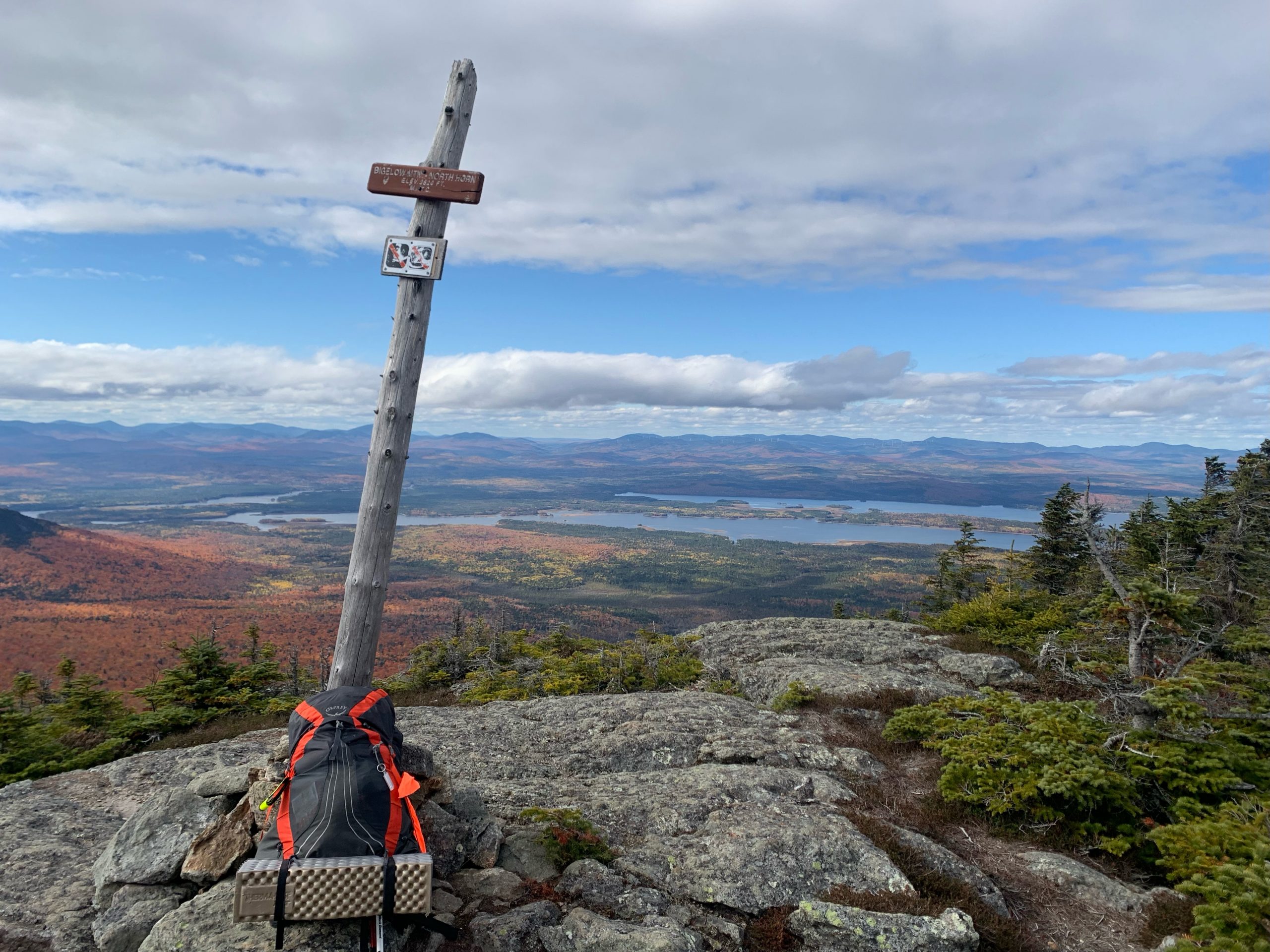
Beyond Horns Pond the AT ascends northward very steeply. Rock stair cases constructed by trail crews – impressive work – offer footing along portions of the way. I reach a 0.2-mile side trail to North Horn, 100 yards before the AT crosses South Horn. North Horn is one of my favored spots in the Maine mountains. Many hikers skip the side trail to North Horn as they have plenty of hiking effort to expend on the AT itself. As for me, I enjoy this first high viewpoint of my journey, and a certain solitude that comes with a mountain perch less visited by others.
Looking northward I trace the course of the North Branch of the Dead River upstream to Chain of Ponds, just south of the Coburn Gore crossing into Canada.
That is the route of the Benedict Arnold expedition in 1775, an attempt to capture Quebec City from the British. North and east along the Bigelow Range, rises West Peak, highest point in the Bigelow, and the highest summit between Sugarloaf and Katahdin. From this angle, the peak points sharply skyward, like a slightly crooked gray-rock finger, reaching above the fir forest that drapes much of the range at high elevation. This profile is quite dramatic. It gives the appearance of a spire so steep that it could summited only with the assist of pitons and climbing ropes. I know that the AT crosses that peak, and therefore is “hike-able”, and I have summited West Peaks on many occasions, but the angularity from North Horn makes the prospect look daunting.
There miles of hiking carry me over South Horn, with its own memorable view of the great mountain mass of Sugarloaf and Burnt Mountains. I reach the high spire of West peak steep, using hands and feet in places to clamber up the last 0.1 stretch of the rock-rubble trail. I top out on a great boulder, where steep slope falls away on all sides. My knees wobble a bit at the “exposure” – a mountaineering term that refers to the “falling away” nature of a slope. (The Knife Edge on Katahdin offers a good example of “exposure”.) The winds have picked up, and converge on my mountaintop perch from all directions – or it seems that way. My knee-wobbling is good, an alert to me to take my time, watch foot placement carefully, as I maneuver a way over the top, down the other side, still on the AT.
I have planned my day to arrive at the Avery Col campsite with no less than one hour to sunset. After picking my way down the steep descent, I reach the site, and set up a simple “cowboy camp”, to sleep under the stars. I carry a small lightweight tarp-tent, but the weather forecast predicts clear sky on a night with a nearly full moon, and of, course, star upon star. Certainly, I do not want to miss that! After a supper of hot stew and biscuits baked at home, I unpack my sleeping pad and sleeping bag, tuck in, pull the tarp over me to ward off the dew, fall asleep under the stars.
After a night of awakening from time to time touched by bright moonlight, and for looks at Ursa Major, Gemini, and neighbor constellations, I wake early, pack up quickly, and head to the summit of Avery Peak to be there at dawn. Quite the sight. I watch the sun top the horizon well beyond Poplar Mountain in the direction of Penobscot Bay, behold the far-reaching shadows the sun throws across the landscape. Quite the light show. Northward beyond Flagstaff Lake the unbroken forest is a kaleidoscope of colors – red, orange, gold, and deep green. Peak after peak rises above long-lying fog – Big Moose, Big and Little Spencer, Number Five and Number Six, Moxie Bald, among them. This is as striking a mountain country sight as I could ever seek. There is not another human being in sight, no structure in sight, and not a sound. The world is utterly still and fresh, and for this day, new.
A plaque near the summit of Avery peak honors Myron Avery of Lubec, Maine, for whom the peak is named. He advocated that the AT, originally to have its northern terminus be Mt. Washington, be extended to Katahdin in Maine. He walked his talk with on-the-ground route planning, the cutting of the pathway, the rockwork, and the trail marking, and the recruitment of volunteers. To this day, volunteers of the Maine Appalachian Trail Club, a trail-maintaining organization, devote thousands of hours annually to care for this historic trail as it passes through our state.

What goes up must come down. Next follows a major descent of nearly 2500’ to Safford Notch, home to a jumble of gigantic boulders that tumbled off the precipitous north slope of Avery Peak. A side tail, which passes through a narrow rock slot, reaches the Safford Notch Campsite. I pause here for water, drawing it from a small stream in the heart of the notch, and purifying it. At this low elevation the trees are hardwoods – white and yellow birch, popple, and rock maple – in various shades of gold. The leaves, bright in mid-morning sun, flutter in a wind that drives through this gap between the main mass of the Bigelows, and the next portion of the range, Little Bigelow Mountain. I traipse through a deep accumulation of leaves, on my way I and out of the notch, and return to a fir-dominant forest on my way over Little Bigelow.
This 3020’ mountain is “little” in comparison to its high-rising, but rugged enough at in its own right, nearly four miles long, with a series of summits. On the second and final high elevation afternoon of my backpacking trip, I sit at high ledge, watch the sun drop towards the Abraham Range. In a reverse of my near-dawn experience on Avery Peak, I give watch westward and to the south, as afternoon shadows reach into the valley of the Carrabassett, and the near slopes of Sugarloaf and Mt. Abraham turn a rich dark green-black in color. Avery Peak, by contrast, a sharp pyramid from this angle of view, all but shimmers in the rich light of the lowering sun.

I sit in silence looking out, when a hawk appears, spiraling up from the valley below. With the sun behind it, it appears as deep black in color, as it beats a way ever upward. I take it to be a Sharp-shinned Hawk, a small accipiter of the north, which prefers remote conifer forest, and locations well away from civilization. Can’t argue with that preference, not on an afternoon like this, here in this set-apart place. I follow the high-spiraling
I follow it as best I can, until it disappears. It has simply flown too high for me to see.
With miles to go and another night’s camp to make, I descend to the campsite of Little Bigelow Lean-to. Along the way I pass through a series of small mountain meadows or stretches of open ledge that offer views northeastward over an arm of Flagstaff Lake. I hike here often in winter by snowshoe on day-trips, to enjoy this view, and the shelter this side of the mountain offers from prevailing winter northwest winds. The campsite lean-to is empty, and thereby available, but I opt again to sleep under the stars and await the rise and travel across the night sky of the fall moon. Another hot stew and more hunks of home-baked bread stoke my inner fires for the chilly night to come.
I am on trail early enough that I reach the Little Bigelow trailhead of the AT well in advance of the appointed pick-up time for a ride home. With that gift of time I hike an extra mile on the AT northward, as it reaches the arm of Flagstaff Lake near Bog Brook. There I step out of the trees onto sandy beach, locate a sitting rock, watch the clear waters of the lake roll in, look towards Flagstaff Mountain in the north, now bright with sun-lit foliage. This is yet another day-hike option – hike north on the AT from the Little Bigelow trailhead.
Whether you go in the days of late fall, or put the Bigelows into your 2023 hiking plans, do consider your own visit to this remarkable terrain. Take a short walk by the streams at the foot of the Bigelow Range. Choose a peak for a one-day adventure. Backpack across part or all of the high ground over a period of days. Perhaps here you will find one of your favorite outdoor destinations, too.
I hope to see you on trail.

Foot and Paddle Tips for Fall Hiking
• Deer hunting season has arrived, and continues in various forms through mid-December. Hikers are advised to wear hunter blaze orange clothing, including a hat, during this season.
• Mountain weather in late fall is quite changeable, with snow and ice possible at high elevation, even when conditions at lower elevation appear warm and free of precipitation. Standard in my fall gear is a sturdy wind and rain repellent shell and pants. I also pack sturdy flexible boot crampons, which are essential in conditions of ice and snow-ice mix. I carry a down jacket with a hood, a wool hat, balaclava, mitts with wool liners.
• I write out my hiking itinerary, including the trail I will take, intended stops along the way, and expected time to complete the hike. This information I leave with a person who will call authorities and take other necessary action if I do not appear as planned.
• A map and compass, in addition to whatever on-line maps and navigation tools, are essentials in my hiking gear, whether on a day-hike or backpack trip. In a group I review with everyone, prior to setting foot on trail, the planned itinerary, tracing the route on a map.
• Keep to a turn-around time. Determine at what time of day turn-around is necessary to turn around in order to be out of the mountains with at least one hour of daylight remaining. Allow the same amount of time to hike out as to hike in. Darkness arrives early in this season, the more so on the east side of a mountain.
Hike well-prepared!
~ Text and photos copyright Doug Dunlap 2022
