


A new hiking season is upon us! Temperatures are warming, footpaths are drying, wildflowers of the North Woods appear in abundance, migrating birds return to fill the hills with call and song, clear and tumbling waters fill stream beds. Time to be on trail.
Waterfall hikes are high on my go-to list, year-round, and one of my favorite destinations is the set of falls on Poplar Stream and South Poplar Stream in Carrabassett Valley. On a bright and warm day, with a northwest cooling breeze, a hiking buddy and I set out to hike a to these impressive falls via trails of the Maine Huts and Trails System. The round-trip hike is an estimated 6.5 miles.
Our starting point is the Airport Trailhead off Maine Highway 27 in Carrabassett Valley, 0.25 mile beyond the Sugarloaf Airport entrance, and adjacent to the Sugarbowl bowling alley and restaurant. In winter this is a popular trailhead for Nordic skiers and those on snowshoes, heading for the Narrow Gauge Pathway or the Huts of Maine Huts and Trails. On this weekday morning in late spring, ours is the first vehicle in the parking area.
The route angles northeastward over the broad field that extends beyond the upper end of the airport runway, to reach the William Munzer Memorial Recreational Bridge over the Carrabassett River. The Bigelow Range commands the northern horizon in dramatic fashion. West and Avery Peaks stand against a cloudless, cobalt sky. Old Man’s Head, an angular cliff juts from at the northeast end of Avery Peak, etched in the fresh morning light. The long, imposing, rampart of Little Bigelow Mountain stretches eastward, its face like that of a great gray and green wall. Quite the sight, and we have barely begun our hike.
At the far side of the bridge, we reach a four-way intersection. A sharp left leads to the Narrow Gauge Pathway, heads along the bank of the Carrabassett River, crosses Huston Brook by a bridge and continues for 5 miles to reach the Highway 27 near the Sugarloaf Access Road. To the diagonal left and immediate right, the Huston Brook Road connects the settlement of Carrabassett Valley, location of the Town Office, with the interior forest along and above Huston Brook. Our route to Poplar Stream angles to the right, and is well-signed as the Maine Huts and Trails route.
Maine Huts Trail to Poplar Stream
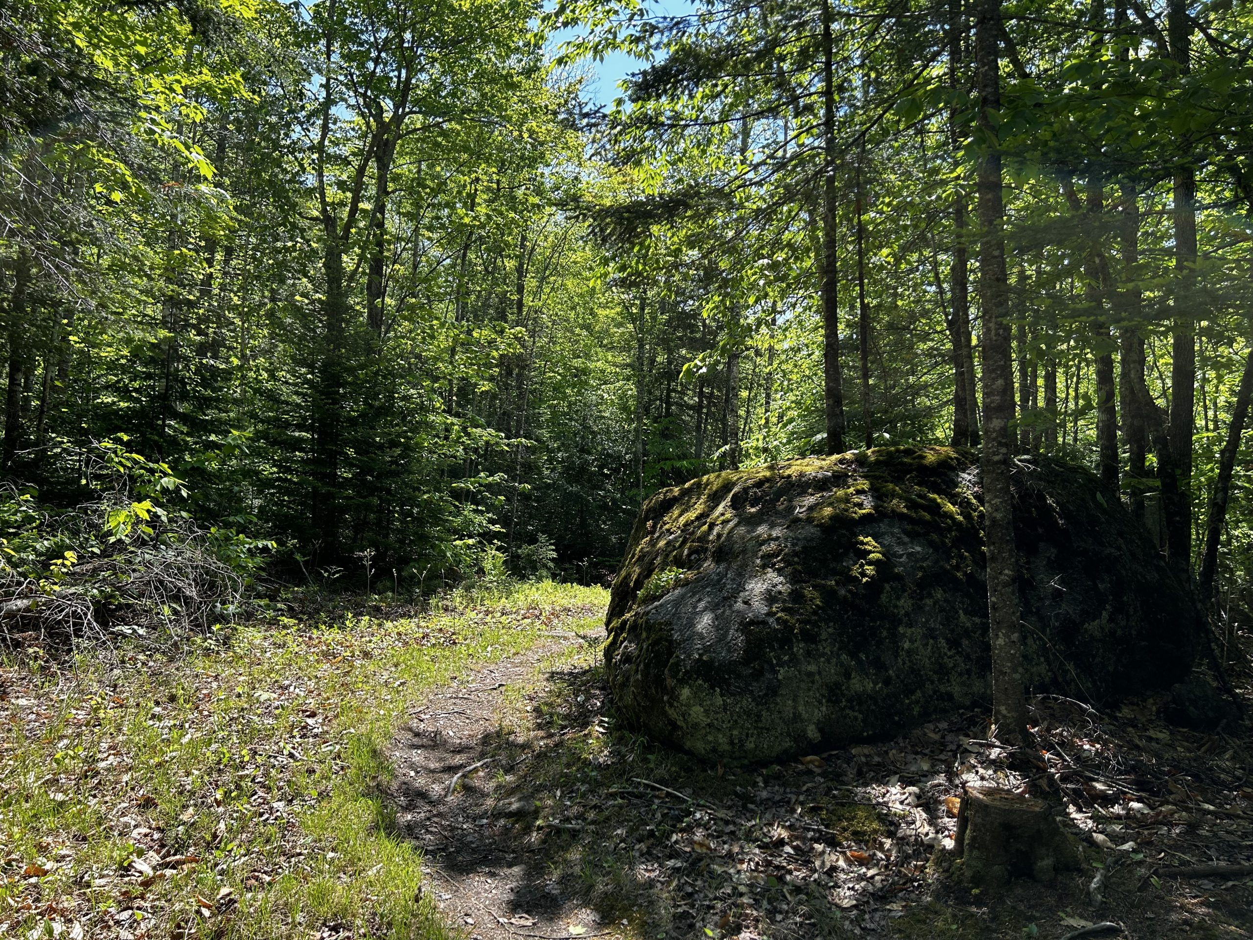
We are quickly into woods, a mix of rock maples and white birch, balsam fir and the occasional red spruce, making a way over what is a Nordic ski and snowshoe trail in winter, and a mountain bike and hiking trail in warm seasons. Glacial erratic boulders, most moss-covered, with ferns growing on their moist tops, lie trailside. Purple trillium, a sure sign of spring; colts foot, another early season flower; tiny bluets; and creamy-white star flowers line the trail. A hairy woodpecker rattles away, a winter wren calls, and an oven bird sings teacher-teacher-teacher. Spring in the Maine Woods!
Twenty minutes of walking over level to gently rolling terrain brings us to a short downhill pitch to a crossing of the graveled Carriage Road, and a bridge over Popular Stream. At the near end of the bridge is a junction with Warren’s Trail, which heads upstream to Popular Stream Falls. That will be the route for our return. Our first destination is South Poplar Stream Falls. For that we will continue across the bridge.
We pause at mid-bridge, for a look upstream and down. Our approach to the day is to be in discovery mode, stopping to watch the rushing water course a way among stream boulders, gather in pools, form back eddies where the current reverses direction, splash, click, rattle.
When I was last here, a few months ago, winter had a frozen lock on the stream. The stream flowed on, under the ice, with a throaty, rumbling sound that echoed in the chill air. No ice today!
The main trail ascends steadily, along a shoulder of Poplar Mountain for an estimated 0.5 mile to an intersection with Larry’s Trail. This is a snowshoe and hiking path which diverges to the left to lead 1.0 mile to the falls on South Poplar Stream. A prominent trail junction sign indicated this to be an alternate route to reach Poplar Hut, which is beyond the falls – and not part of our itinerary for today.
Larry’s Trail follows the remnant of an old logging road, paralleling the stream, and crossing side streams by foot bridges of half-round cedar. We reach South Poplar Stream in 30 minutes, and cross it by a raised planked foot bridge, elevated to limit the chances of being washed away at spring runoff. So noisy is nearby Poplar Stream itself, that I do not hear the sound of South Poplar Stream Falls which quickly come into view. In fewer than 100 yards of hiking beyond the bridge, we reach the base of these impressive falls.
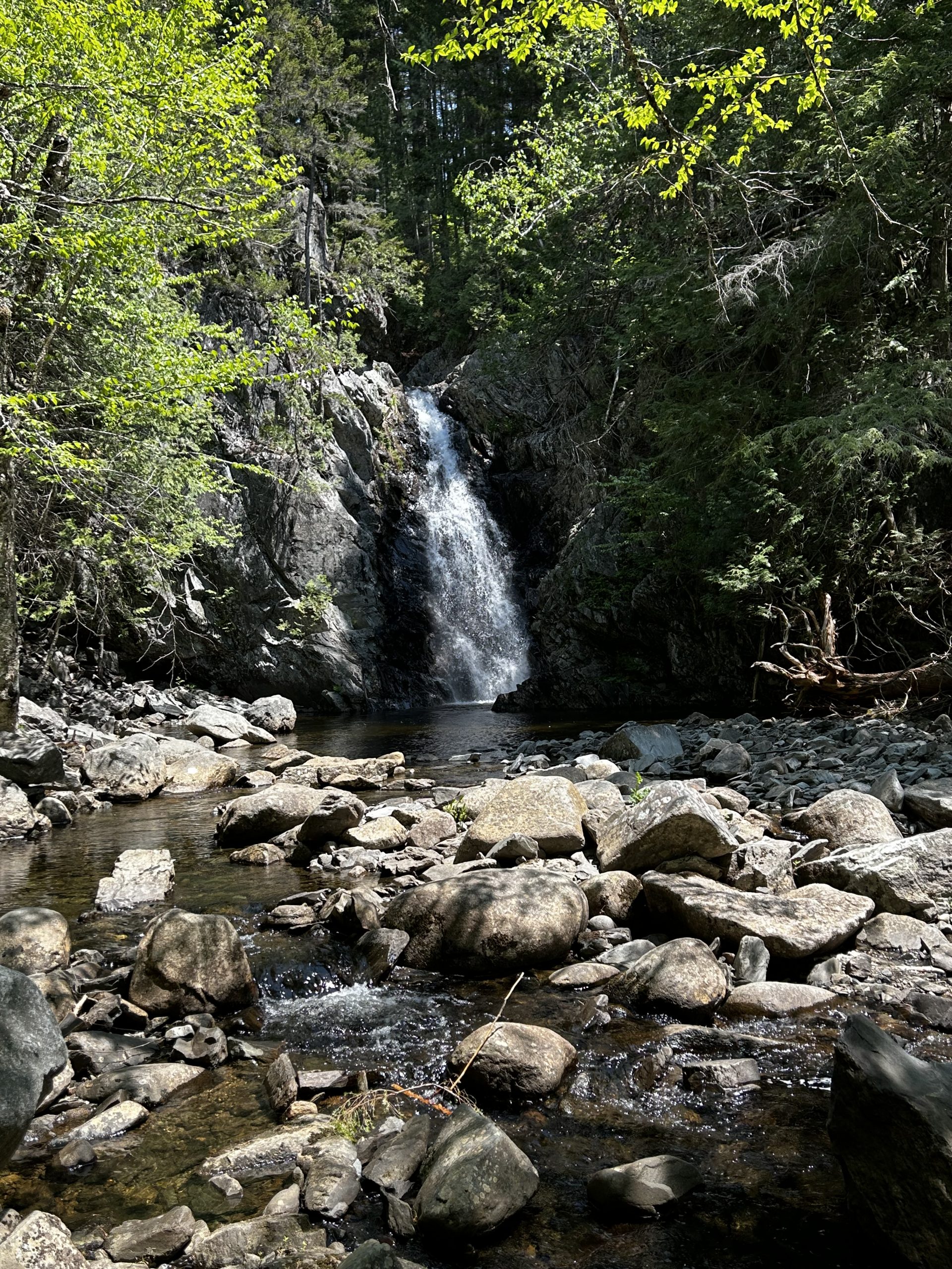
South Poplar Stream Falls
A 50-foot, horse-tail waterfall falls rushes through a water-worn cleft in a high cliff face, to spill into a 30’ pool. Quite the sight – and sound. The water’s roar and splash reverberate off the cliff walls – a natural sound chamber. I strain to hear my companion speak.
Midday sun casts sparkles on the pulsing water. Spray flies into the air. Wave after wave courses outward from the base of the cliff to the edges of the pool, finds the stream opening, courses out of sight. This is the stuff of jaw drops. I find a sitting rock, plunk down, watch, listen. Here is a world apart. Water, gathered up from winter snows and spring rains, tumbles through a gap in a cliff, on its way to the sea. We are quite close to the very source of one of Main’s longest and most well-known rivers, the Kennebec.
The waters with their far-flung, attendant spray nurture life in many forms. Ferns grow in cracks along the cliff face. Trees as tall as 80 feet circle this well-water spot: white cedar, white pine, balsam fir, red spruce, hemlock for conifers. Rock maple, white birch, yellow birch, popple. In nearby woods hobble bush and striped maple make their appearance. Where there is water, there one finds life.
I choose a well-located blow-down log for a lunch spot, in full view of the falls, and take my sweet time listening to the background music of tumbling water. Finally, it is time to go if we are to reach the other set of falls – those on Poplar Stream. I am reluctant to leave this idyllic spot, but there is more to be seen – and who-knows-what to discover.
We continue on Larry’s Trail, ascending a 50’ rock staircase, and reach a signed intersection with Warren’s Trail, a 90-degree turn to the left. (Straight ahead, Larry’s Trail leads in the direction of Poplar Hut.) Warren’s Trail descends to reach the other major set of falls we visit on this hike – Poplar Stream Falls. I pick my way down the short section of rocky trail, with care. As I do on all my hikes, I carry trekking pole. These are very handy to maintain balance on steep pitches. Quickly the falls are in view, and they sing their own distinct song.
Poplar Stream Falls
Quite a different sight! Poplar Stream Falls are of less height than their counterpart on South Poplar Stream – perhaps 25’ high, but much wider. The pool is at least 60’ across, and at its deepest point, is over my head. A short, unmarked side trail – about 20 yards long – begins with a rock staircase, and drops down to the pool from Warren’s Trail. Attention to footing is in order here, to navigate the steep slope, roots, and rocks, but the descent takes me less than 5 minutes. (Alternatively, we could have continued straight on Warren’s Trail, which avoids the pool, reaches a bridge above the falls, crosses the bridge, and descends along the opposite bank. Trail signs guide the way.)

The water is surely cold, but the pool, brightened in full sun, is too inviting to pass up, especially after three miles of hiking on a warm day. Time for a dip. My trekking poles are handy here as well, as I navigate a way over slick and occasionally pointed rock. I have packed a spare pair of socks to serve as water shoes for moments such as this. I don’t want to spoil my waterfront time with a cut foot or a twisted ankle.
The right depth. Plunge time. That gets my attention. Invigorating! Bracing! I come up, return for a second plunge! Re-freshing! I work my way out of the pool, dry off in the heat of the sun. Much fun. Now I am truly ready for the hike out.
The water levels are just low enough that we rock step our way across Poplar Stream below the pool to reach the far bank. Those trekking poles are helpful yet again – for stream crossings such as this, as climbing the steep bank beyond. At the top of the bank, we reach Warren’s Trail, which descends from a bridge crossing above the falls, to parallel Poplar Stream to its end at the Poplar Stream bridge we crossed on our way from the Airport Trailhead earlier in the day. We are about 2.0 miles from that bridge, much of the route, downhill.
Discoveries
I thought that our major discoveries for the day had topped out with our time at the two sets of waterfalls, but spring in the Maine woods is a time of many a revelation, many a surprise. Trailside, we discover a white lady slipper, then another. And another. Next, a pink lady slipper. The trail cuts across an southeast-facing slope drained by small trickling run-off streams and an occasional seep, that render a continuing dampness on the hillside. Ideal conditions for lady slippers. The sun filters through the crowns of the hardwoods, providing the right balance of light and shade. We discover yet more of them. Like a couple of young kids exploring the woods, we continue to be on watch, and we start to keep a lady slipper count.
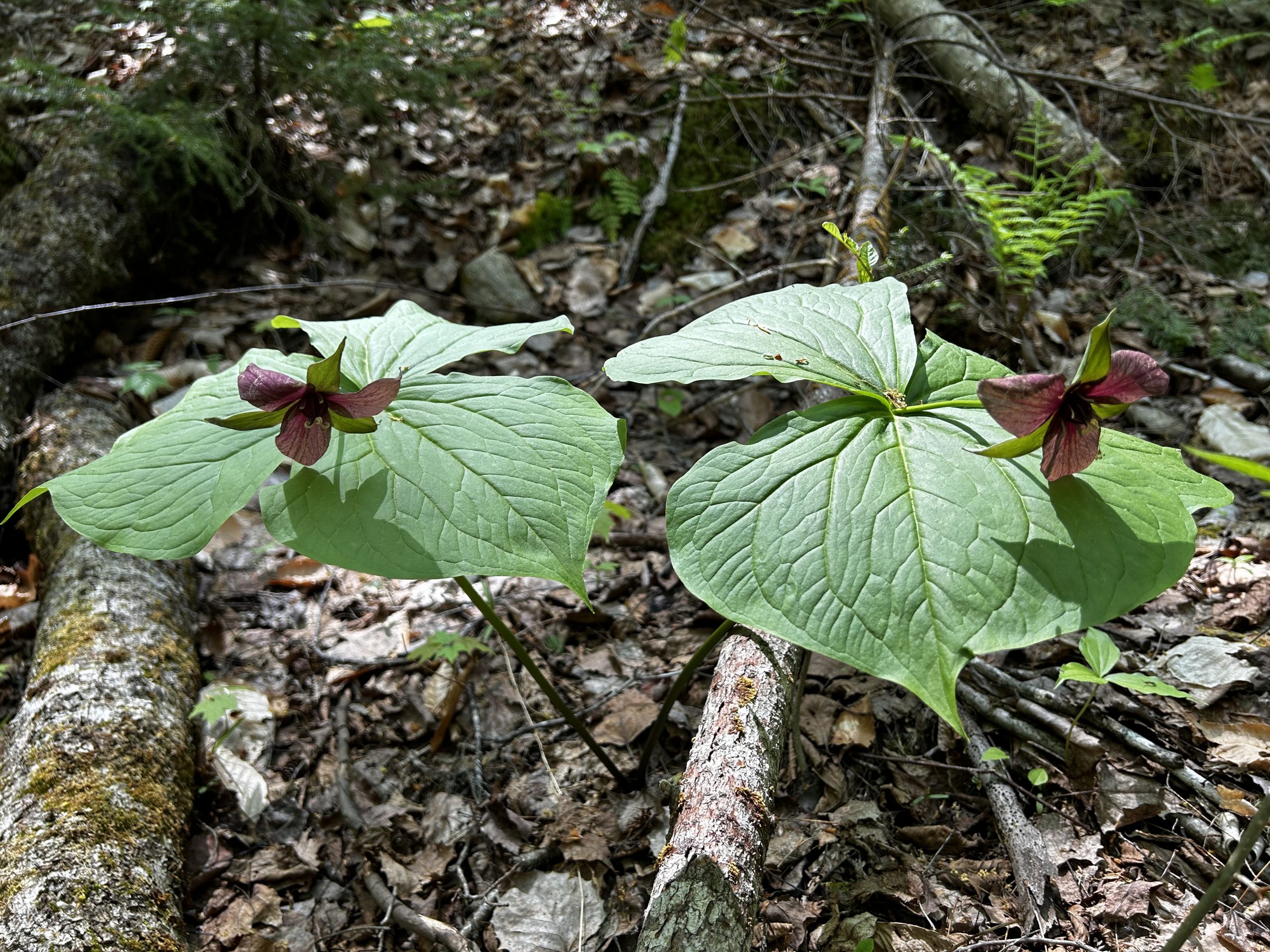
On the alert now, we notice other wildflowers abundant on this forested hillside, as well. Here grow painted trillium, more star flowers, bunchberry. In a muddy section of Warren’s Trail, a line of moose tracks, heads downhill, our direction. We are certainly not alone out here, my buddy quips.
The trail, which had diverted out of sight of Poplar Stream to avoid a steeply ravined section of Poplar Stream gorge, now descends steadily to return to it. We pass twin glacial erratic boulders, each a dozen feet high, young fir growing on their tops. Retreating glacier left those behind 11,000 years ago. Below us, deep pools have formed in the stream below. So clear are these pristine waters that I can see outlines of the stream bottom rocks from well up the overlooking hillside.
What a sweet spot this would be on a hot summer day! No need to fight the beach traffic. Bring a lunch, a beach towel, and hang out here. Take dips in the fresh cool water as the day goes by.
We reach the end of Warren’s Trail at the Poplar Stream Bridge, and the intersection with the Maine Huts Trail to the Airport Railhead. Not so fast, though. We take a break here. I sit by the water, watch, listen, feel the coolness of the stream on my face.
In the final mile of our hike, now in mid-afternoon, we meet two other hikers heading for the falls. They are the only other people we meet on trail this day. When we reach the Carrabassett River, we scout for pools suitable for a cool dip on another day – and find a few. Finally, we return to the Munzer Bridge, cross the river, make our way over the field above the airport, enjoy one more view of the Bigelow Range, still in bright relief against the unbroken sky.
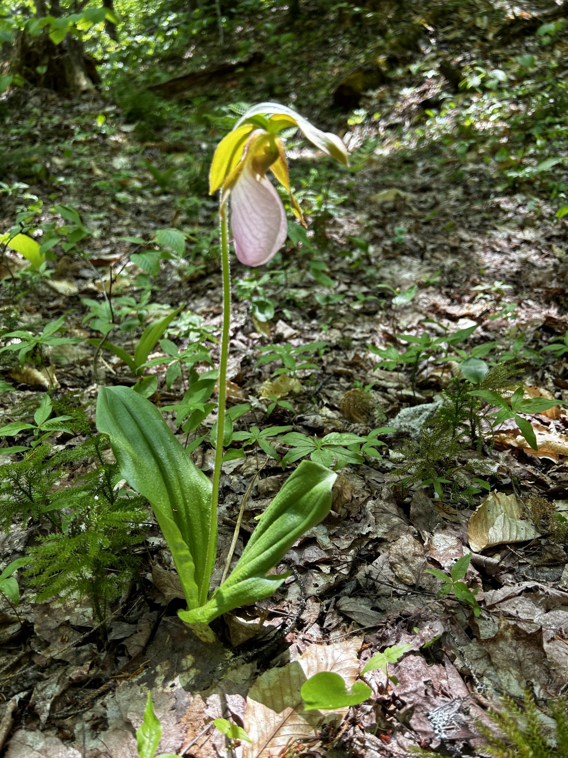
Our lady slipper count? The grand total was 94. If you want to see a few of these magnificent works of nature, head out soon!
What are your hiking plans for this new season? The Carrabassett River and Poplar Stream areas offers many alternatives. Walk for 5 minutes to the Carrabassett from the Airport Trailhead, and explore the pools. Continue for one mile to Poplar Stream, and spend time there. As we did, hike to South Poplar Stream Falls for lunch. Proceed to Poplar Stream Falls if you like, and make the loop back towards the Airport Trailhead using the combination of Larry’s Trail and Warren’s Trail.
Perhaps this is the year when you start a family or friend tradition of taking a hike a week. Walk in silence for a time, watch, listen. Learn a bird call or two. I have accompanied a group of 5th graders from Cape Cod Hill School in New Sharon, on a hike here. Their teachers had each of them find a sitting place in the streamside woods, hold silence, look about, and make a sketch of something that draws their notice. Later they talked of their discoveries. Kids love doing this! The young at heart can be of any age, of course. Come to such a place as Poplar Stream, find peace, bear that peace home with you.
I hope to see you on trail.
Doug Dunlap
—————–
Text and photos copyright 2023
Douglas Allan Dunlap
