


 The building of new recreational trails in Western Maine continues! One of the very newest is the 0.5 mile Prescott Fields Accessible Trail, located in Farmington by the Sandy River on property owned by the University of Maine at Farmington (UMF), and on property of the Town of Farmington. The graded pathway has been constructed for users of wheelchairs, as well as those on foot, and is the first such accessible trail in the Farmington area.
Ribbon-cutting ceremonies on October 15, 2021 opened the new route officially, but I had already traveled on the trail multiple times before that date, and have returned since.
Riverside forest, views up and down the Sandy River intervale, the clear waters of the Sandy itself, an all but picture framed view of downtown Farmington rooftops, glimpses of Mt. Abraham rising far to the north – there is much to see along the way. Many a visitor is discovering the trail to their liking. Each time I am out I meet others who are making an outing on this new pathway part of their daily fresh air and exercise routine, some using a wheel chair or walker, others out for a stroll or jog.
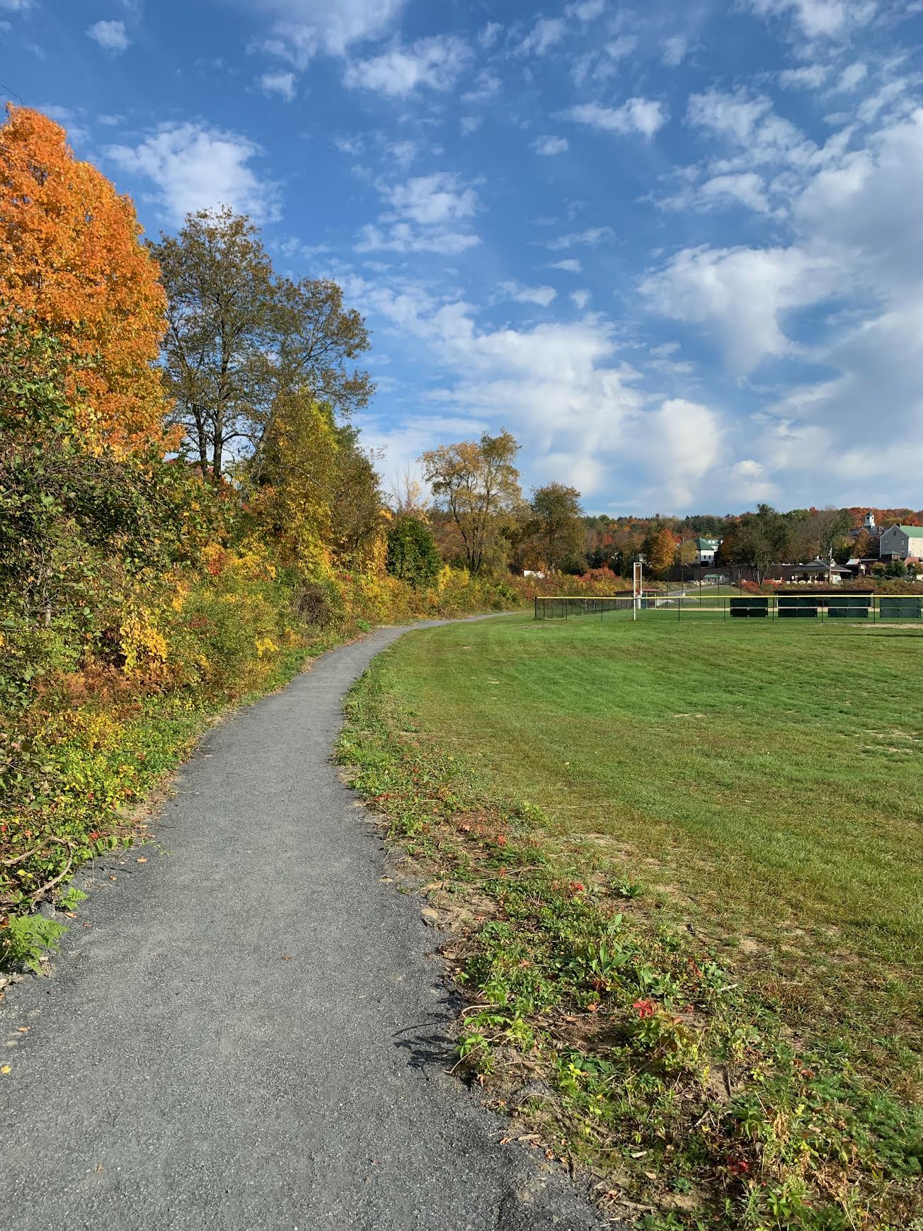
Join me as I explore this well-designed north-south route, which begins in riparian (river shoreland) forest between Front Street and the Sandy River, 0.1 mile north of Gifford’s and MacDonald’s; and 0.1 mile south of the Farmers Union. A prominent sign on the west side of Front Street points the way to the southern trailhead parking area. Here a large signboard provides a map of both the accessible trail, and the larger trail network on Prescott Field and in adjacent areas to the north and the south. On all these routes one is never far from the Sandy River, which of, course, over time carved the river valley, and has deposited rich bottomland soil along the way.
The Trailside Forest

First discovery! This riparian forest is distinguished by massive silver maple trees, 70-80 feet tall, with broad crowns, and diameters of three feet or more. Silver maples thrive near water, and may be found all along the lower Sandy River Valley, but probably nowhere else as prolific as in this niche environment. Although many of these have dropped their leaves as November opens, some of these magnificent trees are still bright with orange and amber leaves. This particular section of woods is crisscrossed by side channels which fill with water at spring run-off or during periods of heavy rain – ideal for this member of the maple family, which unlike many trees, can withstand flooding.
I take my time, inspect individual trees, have a look at the tough, corrugated gray bark, and at the sharply pointed leaves. Leaves of silver maples have the distinctive 5-point maple design, but are more sharply configured. In summer, the leaves have a whitish appearance on the underside, giving the silver maple its name. There are a few red maple and rock maple in this area, usually on slightly higher ground, and I spot a few white ash, but silver maples predominate here.
I am struck by now lush the trailside forest is, even well into the fall season. This riverside setting reminds me of rainforests I have visited around the country, such as in Olympic National Park in Washington; and in Corkscrew Swamp in Florida. I am not claiming that Farmington has trees approaching the size of the behemoths of the Pacific Northwest, or that we should expect alligators and egrets in our corner of the world – but what is common across these environments is the thick ground cover. Contrast this with a grove of pine, or hemlock, such as in the Powder House Hill Trail System, or along the Whistle Stop Trail, to see what I mean. In damp environments, life springs up on nearly every square inch of soil.
Fall Wildflowers and Long Views
More discoveries – and I have barely left the parking lot. White campion, also known as “bladder campion” for the bulge at the base of the white flower, grows in profusion beside the trail. Purple aster, one of the most common fall wildflowers is here, as well. A stand of knotweed, which resembles bamboo, stands head-high, its tiny white flowers still hanging on in fall. Ferns three feet high, which I take to be ostrich ferns, stand on either side of the trail. I need to return with a fern book in hand, as there are many varieties here, some barely one foot in height.
The packed and level surface of the trail is composed of aggregate, quite comfortable underfoot with no rocks and no roots. The route is obvious and easy to follow. In 0.1 mile I reach a planked bridge which crosses one of those seasonal stream beds. Other trails, for walking, intersect from the north and from the south. I continue northward, as the trail winds through the silver maples, to emerge at the edge of Prescott Field itself, with the first views towards town, and across the floodplain that is the location of the UMF athletic fields. This is one of many spots ideal for a stop to take in the long views east towards town, Powder House Hill prominent above it, and north towards the foothills of the Western Mountains.
Nearing the Sandy River
The trail swings back into riparian woodland, and at 0.3 miles reaches a spur to a cobble and sand beach along the Sandy River. This 60’ side trail does not have the same packed surface and is not part of the accessible trail, but the river is in view from the junction, and there is level ground adjacent to the accessible trail that could be a pull-off spot for some users. From my vantage point at the trail junction, I see the reflection of trees along the far bank mirrored in the placid river water, sunlight sparkling on the occasional ripple. Quite the sight!
In another 50’ I reach a turnout constructed with the same aggregate material as the main pathway – another spot to pull over and enjoy the view. A few steps beyond that turnout, another side trail leads down to the Sandy River, by the stone blocks that served as foundation for the railroad bridge that once crossed the river at this point. After recent rains the Sandy is high, and I have a good look at it from the main trail.
Continuing on the Accessible Trail, I make my way along the edge of the UMF athletic fields, with the river on the other wide of a stand of more shoreline silver maples, and some sumac, their fall leaves turned a deep scarlet. I enjoy another fine view of the Farmington skyline. Whatever busyness there may be in town at midday, I hear very little sound. Indeed, the prevailing sound is… no sound, simply the sweet quiet of a path between expansive bottomland fields and the river, the occasional swish of the wind through the trees.
More Tree and Wild Plant Discoveries
As the trail continues northward, it parallels the bottom edge of the old railroad embankment, which with its south-facing location, and protection from chilling north winds provided by the embankment, offers a micro-environment of its own. More purple aster here, some common tansy, more colorfully known as “golden buttons”, and quite a find – the wildflower “butter and eggs”. As the name implies, this flower has two shades of yellow, one like that of an egg yolk; the other that of home-churned butter. There is more! Wild grape, a dark, dark purple; and bittersweet, red and orange, grow in abundance. Who says there is no color in the woods in November?
Further countering that notion, a beech tree stands near the top of the embankment, with its leaves a bright gold. Near that rises one of a series of red oak trees. The leaves of this
rugged tree are a rich red. Adding to the tree display, two chest high white pines stand at the base of the embankment, surely the offspring of towering mature white pine above them, nearly 80’ high. Bring a tree book or app on your outing. This trail has the makings of an arboretum – quite a variety of trees for such a short distance.
Trail’s End
Where I spot the butter and eggs plant I am by the UMF softball field, quiet at this hour and season, 0.4 miles from the trailhead. From here the trail ascends gradually to the top of the railroad bed, passing white granite rip-rap installed on either side to limit erosion. When I top out on the railroad embankment I gain a view up the intervale towards the long field that yields corn and hay crops in summer, and the aligning forest. The north trailhead is at the brick posts and gates by the Big Sky Grille and the Narrow Gauge Cinema, 0.5 miles from my starting point.
The accessible trail ends here. Other trails extend north to the above-mentioned cropland, with views. Users who have spotted a vehicle in this vicinity may conclude the outing here; or return to the south trailhead by either the Front Street sidewalk or a reversal of direction on the accessible trail, for a total of 1.0 miles. Of course, trail users may make this northern end their starting trailhead, and proceed southward, with the Sandy River to the right (west) to the south-lying Front Street trailhead where I began this day’s walk.
Become a Regular
This new trail offers much to see, with its prolific trailside growth, views of nearby hills and of the open sky, and the Sandy in its various water-level moods. As colder weather arrives, it is good to keep moving! This pathway is a fine route to include in a daily routine, wheeling or walking. To those who observe closely, there will be new discoveries for every day on the trail, as the seasons change, the winds vary, plant life proceeds through cycles, and birds and creatures of the woods come and go. For all its closeness to town, this user-friendly route offers a certain solitude, much quiet, and, as I have found, many a discovery.
The Prescott Field Trail system is one of many trails close to our Franklin County town centers. Kingfield has a set of trails east of town across the Highway 16 bridge, in the Stanley Avenue vicinity. Wilton has Kineowatha Park trails near downtown. Phillips is the trailhead for the Fly Rod Crosby Trail, offering a short walk to the Sandy River bridge, and beyond for a moderate walk along the river to the old Sanders Station site of the Sandy River and Rangeley Lakes Railroad. Strong now has a new trail, just north of town, off the Highway 149 to Phillips, which leads down to the Sandy River. In Rangeley, a 0.5 mile trail to the northeast shore of Haley Pond begins at the Logging Museum on Highway 16.
Start your day with a good walk, or close it out with one. Passing through? Lunch hour? No better way to change position and gain some fresh air – perhaps gain some fresh perspective – than to go for a walk in the woods.
We live in the midst of one of the most beautiful landscapes on earth! Find a trail to your liking. Head out! I hope to see you on trail.
