


“Hedge Hog Hill? Where in the western mountains of Maine is that?
In a landscape made notable for its multiple high peaks at elevations exceeding 4,000′, and dozens of mountains at slightly lower elevations with outstanding profiles, long views, or both, Hedge Hog Hill may understandably escape the notice of those who would hike the high ground of western Maine. Yet, this low prominence in Weld – 1,400′ elevation, but with barely a 100′ gain from its surrounding terrain – offers one of the more striking views of the Tumbledown-Jackson Range available from any vantage point I have ever reached. Hedge Hog Hill rises out of the woodlands between Center Hill and Mount Blue, in Mount Blue State Park, reachable by trail, which in winter, is by a cross-country ski trail groomed by park staff.
On a briskly cold day, temperatures in single digits, but the sky utterly clear and bright, I head to Weld with Hedge Hog Hill as my ski destination. The day follows one in which 3″ of new powder snow has fallen from a fast-moving storm. Such are often my days of choice to be in the Maine woods. Fresh snow covers the old, providing the opportunity to discover tracks of wildlife who passed my way only hours, if not minutes, ago. A high-pressure system that typically follows a storm, brings clear skies. The surface conditions are excellent. Heading uphill on skis is all the manageable as there is ample snow depth for good grip. The coverage is such that on downhills there is just enough resistance from the snow depth that I can regulate my speed.
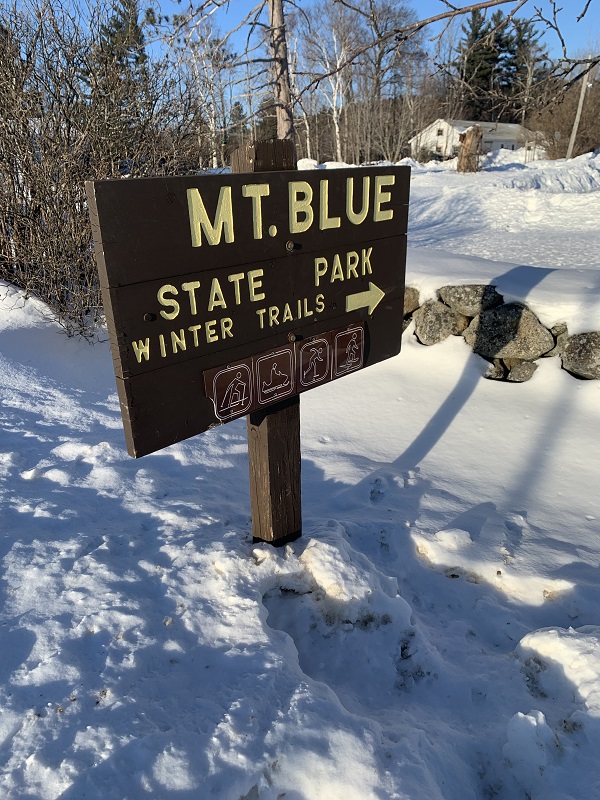
Mt. Blue State Park Ski Trails
Mt. Blue State Park maintains a cross-country ski trail system of about 15 miles. Trailhead for all of the trails is at 299 Center Hill Road, at the well-signed Winter Trails Center. At the downtown four-way intersection, junction of highways 142 and 156, I drive east, following signs for the park.
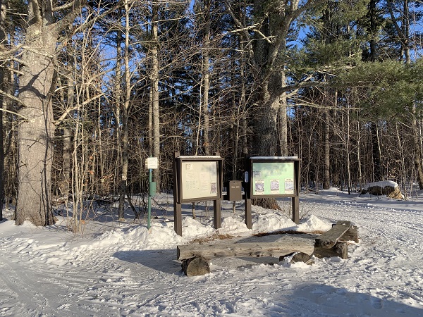
At the crest of the hill, 1.5 miles from town, I reach the open ground with a view to the west over the Weld Valley. To the right, are park winter facilities, including a warming yurt, outdoor ice-skating rink, parking area, vault toilets, and trail system signboard.
Multiple trail systems are served by this one trailhead: cross-country ski, snowshoe, and snowmobile. Each of these modes of travel has its own designated trail, clearly signed. The ski trails are for skiing only – no snowshoes are allowed, as they will obliterate the ski tracks set by the trail grooming equipment. Dogs are also prohibited on cross-country ski trails, a common practice for such trails, for the safety of people and dogs, the integrity of the ski tracks, and for cleanliness. There are deer-wintering areas in this section of the park – another reason for restricting dog presence in the area.
I obtain a map from a box at the trails signboard. Although I have skied my proposed route many times, I find it a good practice always to have a map on hand. One of my “tried and true” standards when I am in the Maine woods, is always to be able to locate myself on a map. Conditions change, blowdowns could render a trail impassable before Park staff become aware of them, or I may meet someone on trail who is in need of orientation. In a lifetime of wilderness travel I have given a map to people who simply did not know were.
There is a self-pay fee station, for cash or check. No credit card system out here. The fees are extraordinarily modest. Before the day is over, I will have skied about 12 miles, over trail packed and with tracks set, by park staff – a precious experience but inexpensive. Fees vary with resident status and age, but will amount to only a few dollars. Certain age groups may use the trails for free.
An important point for skiers. The trails are groomed for skiing by the classic, kick and glide, technique. They are too narrow for skate skiing. It would be unfortunate to arrive without the proper equipment for these trails.
On Trail
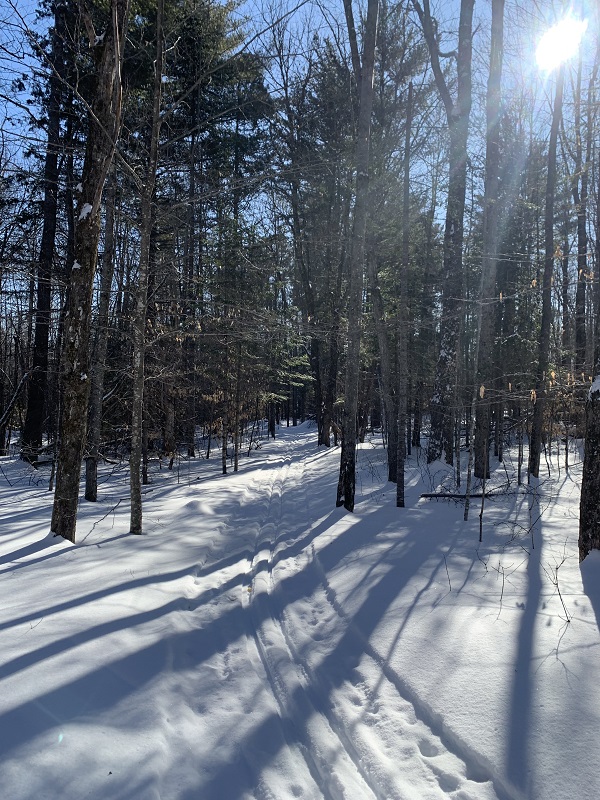
Let’s ski! I start in a grove of white pines, quickly reach an open field where the fresh snow cover dazzles, re-enter the woods. I am on the Central Trail, which connects the trailhead to a half-dozen separate trails. This route crosses the graveled, snow-covered Center Hill Road. I remove my skis when reaching the road, and carry them across. The road has been sanded. Sand and the bottoms of skis do not go well together!
On the opposite side of the road, the trail divides. A left turn leads to the Moose and Fox Trails, with access to the Pine Trails. These pass over terrain that is fairly level, and through a variety of woodlands, including stands of white pine. My plan, a great loop to include Hedge Hog Hill , is via the Birch and Maple Trails. To reach these I continue on the Central Trail by turning right. The trail runs parallel to the Center Hill Road in a bit of roller coaster run – climb, drop, climb, repeat. One downhill pitch I find a bit steeper than I would like. I think this over. I am alone, just starting out, a perfect day. What do I have to gain by just letting the skis run? I side step down the slope half-way, then enjoy the remainder of that run. No twisted ankle for me, if I can avoid it – no thank you.
I reach a junction with the Maple and Birch Trails. Either route will bring me to Hedge Hog. I choose the Birch Trail, a 2-mile loop that connects with the south end of the Maple Trail. I will return to this junction by the Maple Trail. Crossing the road again – removing my skis – I enter the woods and ascend readily over gently sloping terrain, heading south.
Away from the road, the trailheads, and much of the outside world, I enter fully into the realm of the Maine woods in mid-winter. I pass an aged white birch, riddled with lateral holes drilled by a member of the woodpecker family, a yellow-bellied sapsucker. When there is sap to be had, this bird drills the holes and feeds upon the sap. That is not happening today, in m id-winter. This type of woodpecker is soaking up the sun in the Caribbean at this time of year, drilling into trees down there where the sap runs free.
Well Into the Woods
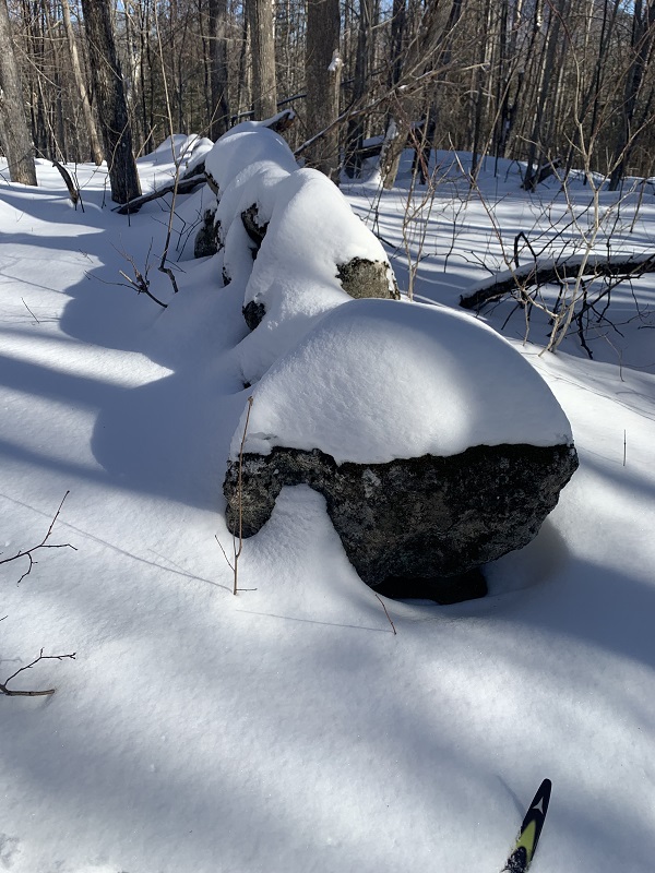
A few more turns of the trail, and I am well into the woods, well away from roads and homes, and sounds there-from. A great quiet abides, save for the occasional creak of a trailside old hardwood swaying slightly in the wind. Speaking of that wind, I see the crowns of trees moving, but at ground level, well-sheltered, I feel barely any breeze at all. Sunlight brightens the bark of white birch, yellow birch, ash, and maple. There are trees here with diameters up to 2 feet. Tracks of snowshoe hare, squirrels, and deer cross my path. Quite the day.
After one hour on trail, I stop for a water break, and to eat a banana. My choice of stopping point is the remnant of an old stone wall, trailside. This area was once farmland. Such stone walls crisscross the landscape. In places I am surely traveling over what was once a roadway, stone walls on either side, now long grown up in the hardwood mix common to this part of Maine, with a few fir and pine to add some winter green. Imagine those farm families in Weld, of an earlier time, on a winter day.
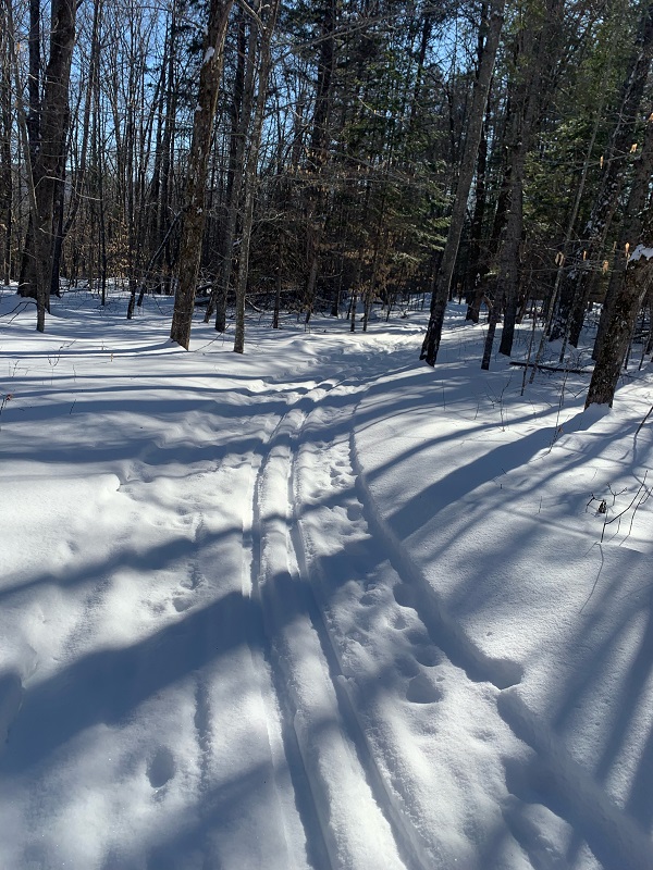
I reach the junction with the Maple Trail, make a downhill run towards a bridge over Fran Brook, and stop for more serous eating – hot soup. Coyote tracks mark a way across otherwise unbroken snow on the brook. On trail again I gain elevation, ski a long stretch southward to the extreme end of the Maple Trail loop, and head northward, in the direction of Hedge Hog Hill. I meet one other skier, the only other skier I see all day, who is traveling the same loop I am, but in the opposite direction. “I never see anyone out here!” she exclaims. We exchanged words about trail conditions and the remarkable beauty of the day, and continue on our respective ways. Eventually I reach a clearing, where with a four-sided shelter and picnic table, stands at the junction with the Hedge Hog Hill spur trail.
Hedge Hog Hill
The distance to the hill top is about 100 yards. I begin the climb on skis, but remove them as the angle of ascent steepens. Walking in my ski boots is fairly easy. I wear high boots and I have built in gaiters on my ski pants, which keep my ankles free of snow. In moments I reach the top of the hill, dream-like in unbroken snow.
Wow!
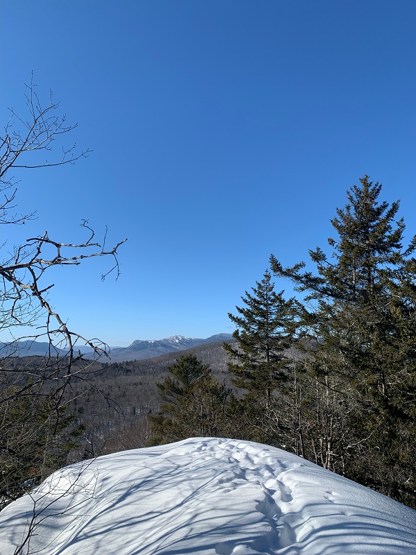
Tumbledown Cliffs, the snow-draped summit of Little Jackson, and the high, forested peak of Big Jackson, loom large to the northwest. Beyond these, beyond the gap of Byron Notch, rise farther peaks – Dolly Mountain, Old Blue. The sky remains utterly clear, an intensely sharp blue. Between where I stand, and these peaks beyond, runs a great expanse of green-gray woodland, vast, still. My friends, this is what I have come to witness, I linger here, until the chill of the day, which I have warded off by the work of skiing, creeps in. It is time to go.
Back to the Trailhead
Down I trek, retrieve my skis, return to the main trail, and ski on. There are still miles to cover, and good miles they be. More woodland, here hardwoods, there, the conifers; more tracks – there perhaps a fisher! I reach the Center Hill Road again, at a point a mile or more from where I last crossed it, hours ago. On the far side I enter an old apple orchard, well gown up now, the apple trees themselves ages past the days when they were pruned, extend their branches in every which way. Other trees have taken root here, as the forest seeks to recover the land as it was before those early farmers cleared it.
Some up and down stretches of trail remain, but I enjoy a long downhill run, westward, toward the sun, before I reach the Maple and Birch Trail junction, continue on the Central Trail. One more road crossing, the gentle ascent across the field below the trailhead, and I arrive at the trailhead and the end of my ski trek.
Before heading home, I walk from the parking area across the road to the Webb Valley overlook – for one more view. Bald and Saddleback Wind Mountains, the long west-lying ridge, Byron Gap, Tumbledown and its mountain neighbors, the broad expanse of Webb Lake below. Quite a day.
————
Winter Outing Tips
When planning a trip to Mt. Blue State Park, check trail conditions by searching online for “Ski Conditions Mt. Blue State Park”
Two snowshoe trails offer fine outings, with good views. The Center Hill Trail and The Rock Trails are each 1.5 miles long (3.0 miles round-trip). Park authorities label these as “strenuous’, recommending allowance of 3 hours each for a round trip.
A closed cell foam pad, the size of a chair pad, can be useful in winter. When I take a break on trail I put the pad on a rock or log to keep my clothing dry, and to avoid heat loss. For open ground where there are no suitable sitting rocks, stumps, or logs, I carry a small tarp I can place on the snow.
Carry a map!
———–
Text and photos copyright Douglas Allan Dunlap 2022
