


Maine Huts and Trails has opened for the winter season, with three of its back country lodges – located in the vicinities of Flagstaff Lake, Poplar Stream Falls, and Stratton Brook – now welcoming overnight and day visitors. I have always enjoyed skiing on the many miles of trail that connect the “huts” over pristine backwoods terrain and amidst the unique deep quiet of the Maine woods in winter. On a brisk, bright morning, I head for the Stratton Brook Hut, atop Oak Knoll in Carrabassett Valley.
Oak Knoll
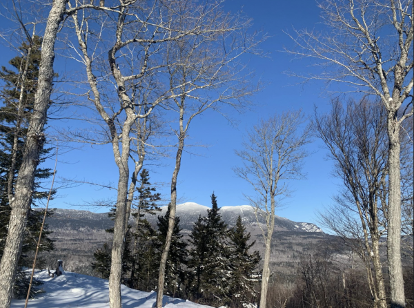
Oak Knoll is a prominent 1,900-foot elevation point on the east-west ridge that rises between Sugarloaf Mountain and the Bigelow range. For those driving Route 27 through Carrabassett Valley, the ridge appears to the right beyond the Sugarloaf Airport. Maine Huts and Trails has located the Stratton Brook Hut on the knoll, which offers striking views of 4,257-foot Sugarloaf in one direction, and 4,150-foot West Peak, 4,088-foot Avery Peak, in the Bigelow range, in another. As for Stratton Brook itself, there is a fine vantage point near the hut from which one may look down at the stream and its elongated pond – hence the name of the hut.
I have made the ascent to the hut in all four seasons, usually for a day outing, but did enjoy an overnight here a few years ago when walking from Farmington to Lac-Mégantic, Québec. The hut is a fine destination for overnight trips into this striking setting, between the Bigelow and Sugarloaf ranges. It also serves as a good objective for an in-and-out day trip for those on snowshoes or backcountry skis. Drinking water is available, and there are good vantage points inside and outside the hut for a look at the remarkable view. Those on skis should be prepared for an elevation gain of 600 feet or more, depending upon the trailhead chosen, and be competent to ski in control on the winding downhill stretches.
On a winter day that promises to be bright, clear, and briskly cold, I wax my Nordic skis for cold temperatures, pack a day pack with extra gear for cold conditions, and head for the trailhead at the upper end of the Sugarloaf Airport. Signed as the Airport Trailhead, this spot is adjacent to the Sugarbowl bowling alley and restaurant. The trailhead parking area has a vault toilet and a signboard depicting the trail system of Maine Huts and Trails. From here the heights of Oak Knoll and Stratton Brook Hut are 5 miles or 6.8 miles, one way, depending upon choice of route, which I explain below.
The Airport Trailhead
There are two other trailheads farther north off Route 27, at Campbell Field opposite the Sugarloaf Outdoor Center and at the Stratton Brook Hut parking area 0.2 miles north of the Sugarloaf Access Road. Distances to the knoll and hut are shorter from these starting points, 3.2 miles each. With a number of long ski outings under my belt this season, and with ideal conditions presented by a 3-inch snowfall the day before, I opt for the longer distance, and start at the Airport Trailhead.
The temperature is 20 degrees as I start out, but the wind is fierce, blowing the freshly fallen snow into billows. The Bigelow Range looms beyond the upper end of the valley, its summits hidden by blowing snow. The wind rattles my snow-shell outer layer, sending me into my pack for a balaclava, ski goggles, and wool liners for my mitts. Once I reach the woods on the other side of the Carrabasett River, I will have protection from the wind. I have to get there first! Head down, I follow ski tracks made by others in recent days, across the open field beyond the landing strip, to the recreation bridge over the Carrabassett River. On the far side a trail junction provides the option of heading towards Poplar Hut, or towards Stratton Brook Hut. A logging road crosses here, as well. There is ample signage. First time visitors should confirm that they are headed in the correct direction.
I turn left, with the river now on my left. I am used to seeing open water on the Carrabasett River all through winter, but recent deeply cold temperatures have frozen the river nearly all the way across. A trickle of water rises out of a crack in the ice, slips over the ice surface for a few feet, disappears into the running water below. I would, of course, never attempt to cross the Carrabassett in winter. It is a surety that the ice is quite thin in places. The swift current underneath would make a rescue exceedingly difficult.
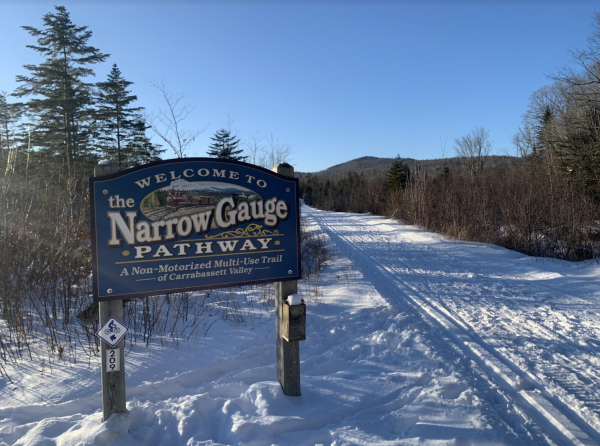
The ski trail stretches before me – the straight line of the Narrow Gauge Pathway, which in another era was the railroad bed of the Narrow Gauge Railway. This was the route by which logs from the upper valley were hauled to mills situated to the south in Franklin County and beyond. Imagine those days! I cross north-to-south running Huston Brook, ice-covered, by a wide foot-travel bridge. Off I go, kick and glide, eager to ski and eager to work up some heat.
Choosing a Trail Less Traveled
In a quarter mile I am well within the trees, and out of the wind. I see the tracks of one other skier ahead of me, but no one is in sight. One mile from the bridge I reach a signed trail junction. The Narrow Gauge Pathway veers slightly left, where it will return to the bank of the Carrabassett River in 0.5 mile, in a gradual ascent along the old railroad bed. By this route, Oak Knoll is 5.5 miles.
The trail to the right, my choice, ascends steadily in a more direct line to the hut, reaching it in only 3.8 miles. There is no sign that provides a name for this trail, but it has been variously known as the “Narrow Gauge By-Pass” and the Crommett Trail. This “bypass” route ascends more steeply than does the Narrow Gauge. The fresh snow cover has not yet been groomed. The accumulated powder should offer good grip for my skis – if I have waxed properly. The steady ascent will require some work, but I am still a bit chilled, and the uphill effort will help me to generate some heat.
Off I go. I appreciate for my choice of route, as I soon enter supreme quiet, far from the even occasional traffic sounds from the distant highway. I gain good grip in the snow, and am even able to ski uphill over much of the way. The low winter sun throws shadows of bare rock maple, ash, white and yellow birch, across the way. Beech add the color of their amber leaves. The firs, and occasional hemlock, and some high white pines up to 3 feet in diameter, wear snow on their branches. Quite the sight.
Track of snowshoe hare, red squirrel, and field mice cross the trail. So too, do I see the track of fox, and of fisher. Here and there the plunging tracks of deer cross, too. Busy place here, but quietly so. Such a day: sun, shadow, fresh snow. As I gain elevation, I catch glimpses of the twin peaks of West Peak and Avery Peak visible through the bare canopy of the hardwoods. The sky beyond them has cleared to a sharp blue. The trail winds through the mixed growth forest, occasionally dropping into a draw, only to ascend again. It is good to let the skis run a bit in between stretches of uphill work.
At a distance of 1.8 miles from the trail junction I reach another signed junction for a trail that drops to my left 0.4 mile to connect with the Narrow Gauge Pathway, which I am above, traveling in parallel to it. I have taken that connector on other days, sometimes to make a short loop and return to the airport area, and at other times simply to do some exploring. Part way down that connector trail there is a fine stand of larch. Larch is the one coniferous tree in Maine whose needles turn orange and drop in late fall – a deciduous conifer. Come back toward the end of October to see the dramatic color.
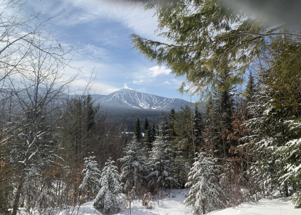
I continue upward, 2 miles remaining to reach the heights of Oak Knoll. The forest opens to a broad view of Sugarloaf and adjacent Burnt Mountain, where a no-longer-used hauling road from a logging operation cuts across the trail. This is the on-foot version of “Oh my gosh!” corner on Route 27, where the north face of Sugarloaf suddenly appears. Worth a stop here.

Crommett Overlook
Twenty minutes past this viewpoint I arrive at the Crommett Overlook, and another exceptional view of Sugarloaf. The site memorializes the late Dick Crommett of Carrabassett Valley, who founded the Carrabassett Outdoor Club. A plaque honoring Dick is affixed to a trailside picnic table. This is one of my favorite views in our western Maine mountains. I often seek to imagine the days before there was a ski area on Sugarloaf. It is one massive, impressive peak, so imposing that once the entire high ridge from Sugarloaf south to Spaulding Mountain was once all considered to be “Sugarloaf,” Franklin County’s highest peak. Sugarloaf is Maine’s third highest mountain, after Katahdin and Hamlin Peak in Baxter Park.
I pause here, but not for long, as I notice a drop in temperature, and need to go back to work to warm myself. Much of the trail from this point is uphill. I am having the time of my life: fresh snow, long views, sublime beauty. Remarkably, I have not seen another person on this entire outing. I enjoy this haven in the Maine mountains as a solo traveler. It seems a certainty that there are people skiing and snowshoeing on the Narrow Gauge Pathway which is a good mile and a half below me as the raven flies.
Newton’s Revenge – Gravity
The next trail junction is with Newton’s Revenge Trail, an alternate route to Stratton Brook Hut from Route 27 trailheads below and above the Sugarloaf Access Road. This trail gets its name from its steepness, as in Isaac Newton and gravity! My last 0.7 miles of ascent is via Newton’s Revenge. I turn right at the signed junction, and head up. The ungroomed powder continues to afford me good purchase or grip, and to move along steadily. Now I am too warm, while surely generating that sought after heat. I pull back hood on my shell parka back, and remove my balaclava to dump some of that heat. The trail corkscrews upward to pass a north-leading trail that heads 7 miles to the heights of the Bigelow Range, and another that winds down to Route 27 on the west end of the Knoll. I pass a stand of red oak, leafless now in mid-winter, which give the knoll its name, and reach the hut.
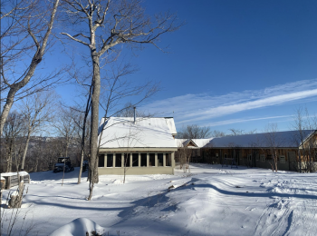
Stratton Brook Hut
Stratton Brook Hut consist of two buildings joined by a covered breezeway. One is the main lodge with a gathering room, dining room, kitchen, toilets and showers. The other building houses sleeping rooms. The lodge offers a striking view of West and Avery peaks through the high windows of the gathering room. Step outside, face south and there is Sugarloaf. Side trails lead to viewpoints of the full length of the Bigelow Range, and the Stratton Brook area well below. To be clear, there is no brook on the top of this knoll! Instead, there is a view – a fine one – of distant Stratton Brook, two miles off, at the base of the Bigelow Range.
I am about to enter the hut when the trail grooming crew arrives, having followed my route up from the Airport trailhead by snow machine, pulling a grooming platform behind. Inside we are greeted by the hut host, a woman from Colorado who has come to Maine for the winter to work for Maine Huts and Trails and to enjoy our mountains. As I eat the hot soup I have packed in an insulated container, the four of us exchange stories about places we have hiked or paddled in the west and in Maine: the western slope of the Rockies; the Allagash and Baxter Park in Maine.
The hut is open on weekends on a full-service basis, providing meals and overnight lodging, including hot showers and environmentally-friendly toilets. The gathering room or “great room” has a wood stove, comfortable furniture, and a small library. On week days, a form of self-service is available, at a reduced cost, which includes lodging and the use of the kitchen facilities for overnight guests to prepare their own meals. (Details at mainehuts.org)
There is no fee for use of the extensive trail system. However, I always leave a financial donation, as trail maintenance and grooming require personnel and equipment. I am grateful for the opportunity to ski, snowshoe, or hike the many miles of remote trail. There is a donation jar at the hut. If I do not have funds with me, I mail a check to the home office in Kingfield (mainehuts.org).
Fed and watered, I am conscious of the time, and the fact that the temperatures are predicted to drop. I say goodbye, as the groomers leave to continue their work. For the descent I pull out a down parka, and fashion the balaclava over my head. I will not be generating much heat on the descent. Down I go over the corkscrew-like trail, on a well-groomed surface that is more readily maneuverable on the downhill run than would have been the case in on 3-foot powder before grooming.
The Descent
My plan is to descend Newton’s Revenge all the way to the Narrow Gauge Pathway, and follow the Pathway all the way back to the airport, thereby to complete a great loop of about 12 miles. Alert for uphill travelers, I zip downhill, checking my speed to maintain control. I reach the Gauge in not much more than 30 minutes.
Here I turn left and get into a kick and glide rhythm over the fairly level surface, with its slight downhill cant. I meet other skiers for the first time today near the Campbell Field connector trail, but on my entire run back to the airport I see no more than a half-dozen people. There is a noticeable drop in the temperature, which may be deterring people from coming out.
I find my skis to be running slower than I would expect on this long downhill run, and that is because my ski wax for the day is in the teens’ temperature range. As the afternoon turns toward evening, cold is settling in, and temperatures are heading towards single digits. This is not a problem, as I still make good time – but noticeable.
The sun hangs just above a long ridge to the southwest, as I reach the open ground by the airport trailhead. In my final quarter mile I ski in shadow. If I had been delayed for some reason, I carry a headlamp and spare batteries – two headlamps, in fact – standard gear for winter outings. Once I return to my truck I sip from insulated bottle of hot tea, still hot after my many hours on trail.
This has been as fine a winter day in the western Maine mountains as I could ever want. For those of you who live in Franklin County, or are here to visit, this magnificent woods and mountain terrain is right in our backyard. I hope to see you on the trail!
Tips for winter outings
What’s in your winter daypack? Mine includes drinking water, packed inside the pack – not in the external water bottle holders – in water bottles placed inside wool socks to prevent freezing. An essential way to generate warmth is to eat frequently. Every 60 minutes I eat an apple or banana, half a bagel, an energy bar – preferably home baked – some nuts or some cheese. In strenuous winter activity a person in the outdoors can burn 5,000 calories. Without hydration (water) and food, a person can tire quickly as the body struggles to perform.
In case I have a mishap – equipment problems, or perhaps a turned ankle – I carry extra clothing layers, a “space” blanket; a small section of insulated pad to sit on, spare socks, an extra battery for my cellphone, and fire-starting material which could function as both a signal and a source of warmth. Other gear includes a multi-tool for repairs, hand warmer pads, spare mitts, and a first aid kit. I have already mentioned the headlamps and spare batteries.
On most winter hikes I do not need to use most of such gear. But when I need these items, which I have from time to time over the years, I really need them. I just never know when that will be, and therefore I carry them all the time.
Be safe out there!
Text and photo copyright Douglas Allan Dunlap 2022
